Alma gives birth to Arthur
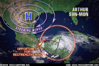
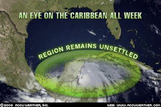
Tropical storm Alma crossed over Central America into the warm waters of the Caribbean and strengthened into tropical storm Arthur, the first named storm of the Atlantic season. As the graphic clearly shows, there is no threat to the US gulf coast due to a strong high pressure system located over south Texas.
 The projected storm track has Arthur curving to the west, crossing over the Yucatan peninsula and entering the Bay of Campeche in the southern Gulf of Mexico on Sunday or Monday.
AccuWeather reports that the name of the storm changed from Alma to Arthur because Alma dissipated completely over Nicaragua. When the storm reformed, it was given a new name from the list of Atlantic storms for 2008. It is likely that Arthur will again dissipate over Belize and southern Mexico before strengthening one more time once he enters the Bay of Campeche.
The high pressure steering currents will keep Arthur in southern Mexico. I wonder if the high moves to the northeast, could Arthur venture northward? Even if he does, I do not think we will see much of a problem as the sea temperatures are still rather cool so strengthening beyond a possible category 1 hurricane at most is all we will see and that is only if the high moves out of the way. My prediction is that Arthur will stay below 50 MPH and die out by mid week. Let's just hope that the rainfall amounts do not generate too much rain or excessive flooding. As slowly as this storm is moving, flooding is the key this to watch for.
Tropical Storm Arthur, 1st of hurricane season, hits Yucatan
AMBERGIS CAYE, Belize — A weak tropical storm formed Saturday off the Yucatan Peninsula and quickly made landfall at the Belize-Mexico border, dumping rain and kicking up surf. The first named storm of the 2008 Atlantic Hurricane Season, Arthur was moving northwest across the Yucatan with maximum sustained winds near 40 mph (64 kph), according to the National Hurricane Center in Miami.
The storm formed one day before the official start of the season June 1, hitting land near the Mexican port city of Chetumal and Belize's Corozal city. It dumped rain as far south as Belize City and kicked up strong surf on the popular tourist island of Ambergis Caye. Tropical storm warnings were issued for Belize and Mexico's Caribbean coastline.
The first tropical system of the season in the Atlantic Basin is expected to drop heavy rainfall on parts of the Yucatan Peninsula over the next few days. Arthur is expected to take a westward track thanks to a ridge in place over South Texas. This track will keep it on land and take it through southern Mexico, posing no threat to the United States. Parts of Belize, Guatemala and Mexico are expected to receive 5-10 inches of rainfall with the highest amounts closer to 15 inches from this system.
FINAL UPDATE:
The national Hurricane Center has stopped issuing advisories on Arthur. The storm has essentially disintegrated over the Yucatan peninsula and southern Mexico and has not re-emerged over water as originally expected. The key issue is going to be heavy rains and heavu flooding. AccuWeather is predicting as much as 10 - 12 inches of heavy rains in mountainous regions of Guatemala which could result in life threatening floods.

Storm Watch with: Outside the Beltway, Rosemary's Thoughts, 123beta, Right Truth, Big Dog's Weblog, Leaning Straight Up, The Amboy Times, Cao's Blog, Democrat=Socialist, Conservative Cat, Adeline and Hazel, Allie is Wired, Faultline USA, third world county, Woman Honor Thyself, McCain Blogs, The World According to Carl, Pirate's Cove, Blue Star Chronicles, The Pink Flamingo, Wolf Pangloss, , Right Voices, and The Yankee Sailor, thanks to Linkfest Haven Deluxe.
<< Home