Tropical Storm Norman

UPDATE (10/16/06):
Click on the title link for a report from KHOU-TV Channel 11 in Houston. Includes weather forecasts for the area, storm warnings and reports on the flooding and other damage. As of 5 pm there have been 4 deaths from this storm.

Severe Weather slide show part 1, KHOU-TV
Severe Weather slide show part 2 KHOU-TV
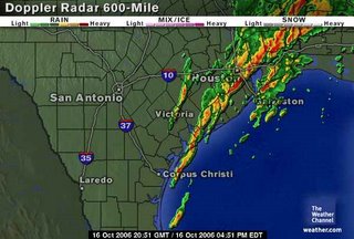
These storms are all th result of moisture that was Tropical Storm Norman that is crossing Mexico and inundating southeast Texas and southwest Louisiana with heavy rain. A front is located near the northeren part of the state and is helping to push the storms south and east through Houston and Beaumont, TX and Lake Charles, La.
Norman was downgraded on Sunday as shown in the graphic below. At least this eliminated some of the wind. The worst we saw were gusts up to 34 MPH throughout the day.
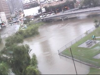
The rain came in early Sunday morning and we've had some periods of heavy rain with several breaks in between. Monday has been much worse with street flooding and several flood, flash flood and tornado warnings throughout the day. In my area we received 5+ inches, but parts of Houston have as much as 10 - 12 inches. Several schools are closed for the evening.
As of now the weather services are all predicting the portential for rain to decrease this evening and tomorrow should be partly cloudy.
================================================================
 Tropical storm Norman has formed in the eastern Pacific and os heading for the southern tip of Baja California. From the NWS projections, it looks like this will be nothing more than a rain event. I'd be surprised if there is any damage except possibly some street flooding.
Keep an eye out for heavy rain in the southwestern US sometime around the end of next week. These areas have been inundated with rain this summer so flooding can be a big issue.


<< Home