


Hurricane Season 2006 is slowing down
 After all the dire predictions of how 2006 would be a very intense hurricane season with a high potential for a major hurricane hitting the east coast and possibly New York City, the year has basically turned out to be an average season.
The latest predictions are that we will see up to three more named storms with one possibly reaching hurricane strength but none are expected to affect land and they are expected to remain relatively mild.
I think there were two major effects that helped to lessen this year's storm season. 1. The area of high shear in the Gulf of Mexico and the Carribean remained in place far longer than had been predicted. 2. The typical Bermuda High that helps establish the steering currents that force the storms into the Gulf never formed this year. Instead we had alternating periods of low pressure systems off the east coast of the US or a stationary front that acted to block storms as they approached the US.
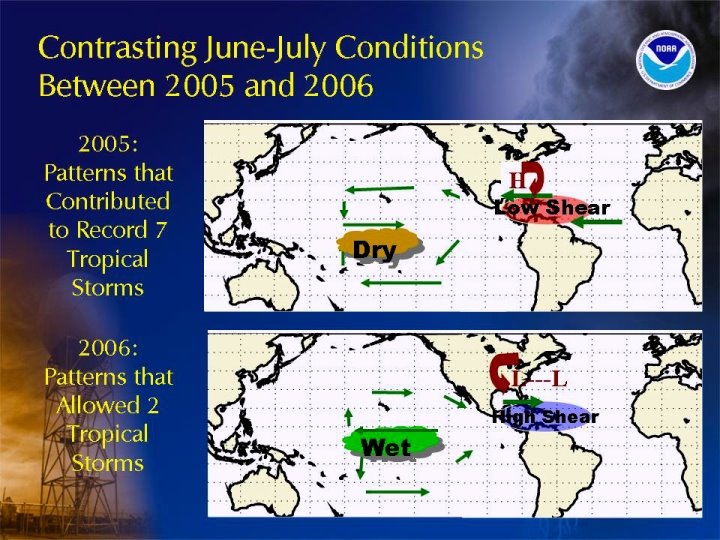
High pressure systems rotate clockwise in the northern hemisphere. As a storm approaches a high located around Bermuda the rotation of the high acts to convey the storm right into the Carribean Sea and either Central America or the Gulf of Mexico. This year the Bermuda High never formed. Instead there were many low pressure systems located along the east coast.
Low pressure systems rotate counter clockwise in the northern hemisphere causing the storms that did form this year to be driven north in the center of the Atlantic.
So with a combination of the high shear and the low pressures off the coast this year's hurricane season has essentially ended up being much ado about nothing.
Of course we all really know that it is actually Karl Rove's doing - that
he manipulated the weather to create a mild hurricane season to benefit the
Republicans in the mid-term elections :-)
Not quite ... and ... just as last year's season by itself in no way demonstrates a link between global warming and hurricane frequency and strength (as Al Gore's movie states), this year's does not disprove a link either. Next year could be another strong season and it may certainly be due to the Atlantic Multidecadal Oscillation the data for which is far more reliable than the data predicting man-made global warming.
Trackbacked to: Dumb Ox News, Woman Honor Thyself, Plancks Constant, 123beta, Diane's Stuff
posted by KWR | 12:39 PM
![]()
![]()


<< Home