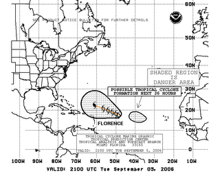
TD #6 becomes Tropical Storm Florence

The 6th named storm of the season formed in the Atlantic this morning. Tropical storm Florence is expected to strengthen and become a hurricane within a couple of days. The area of the North Atlantic where the storm is now has a good deal of wind shear so the potential for further organization is likely low for a couple of days. By the end of the week, Florence should be a Cat. 1 hurricane.
On its current projected pathway, the storm is heading for the southeast US coast and may even strengthen, but it is way to early to predict landfall. Most of the computer models are predicting that the storm will actually turn north and possibly stay away from land. Again, it is really too early to tell which way the storm will head as it gets closer to land. Next weekend will provide us with a more accurate forecast of both direction and intensity.
 It is important to note that right now (Tuesday evening), a tropical wave is located further east of Florence and could develop into a tropical depression over the next few days. September is the month where we will typically see storms steadily flow off the wester coast of Africa and develop as they move across the ocean. Dr. William Gray of Colorado State is predicting that September will see as many storms as we have had so far all season (see earlier post). We will have to keep an eye out across the Atlantic to see how things develop.


<< Home