Gulf Coast Hurricane Tracker

A single source reference on tropical weather predictions. With a traditional focus on the upper Texas and Louisiana Gulf Coast we've maintained links to track all Atlantic Basin, Caribbean and eastern Pacific storm systems. We are now expanding our view to tropical storms throughout the world intending to be a comprehensive global storm tracking resource.

Saturday, May 31, 2008

Alma gives birth to Arthur

Tropical storm Alma crossed over Central America into the warm waters of the Caribbean and strengthened into tropical storm Arthur, the first named storm of the Atlantic season. As the graphic clearly shows, there is no threat to the US gulf coast due to a strong high pressure system located over south Texas.

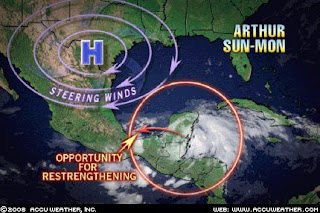
The projected storm track has Arthur curving to the west, crossing over the Yucatan peninsula and entering the Bay of Campeche in the southern Gulf of Mexico on Sunday or Monday.

AccuWeather reports that the name of the storm changed from Alma to Arthur because Alma dissipated completely over Nicaragua. When the storm reformed, it was given a new name from the list of Atlantic storms for 2008. It is likely that Arthur will again dissipate over Belize and southern Mexico before strengthening one more time once he enters the Bay of Campeche.

The high pressure steering currents will keep Arthur in southern Mexico. I wonder if the high moves to the northeast, could Arthur venture northward? Even if he does, I do not think we will see much of a problem as the sea temperatures are still rather cool so strengthening beyond a possible category 1 hurricane at most is all we will see and that is only if the high moves out of the way. My prediction is that Arthur will stay below 50 MPH and die out by mid week. Let's just hope that the rainfall amounts do not generate too much rain or excessive flooding. As slowly as this storm is moving, flooding is the key this to watch for.

Tropical Storm Arthur, 1st of hurricane season, hits Yucatan


AMBERGIS CAYE, Belize — A weak tropical storm formed Saturday off the Yucatan Peninsula and quickly made landfall at the Belize-Mexico border, dumping rain and kicking up surf. The first named storm of the 2008 Atlantic Hurricane Season, Arthur was moving northwest across the Yucatan with maximum sustained winds near 40 mph (64 kph), according to the National Hurricane Center in Miami.

The storm formed one day before the official start of the season June 1, hitting land near the Mexican port city of Chetumal and Belize's Corozal city. It dumped rain as far south as Belize City and kicked up strong surf on the popular tourist island of Ambergis Caye. Tropical storm warnings were issued for Belize and Mexico's Caribbean coastline.

UPDATE: From AccuWeather.com


The first tropical system of the season in the Atlantic Basin is expected to drop heavy rainfall on parts of the Yucatan Peninsula over the next few days. Arthur is expected to take a westward track thanks to a ridge in place over South Texas. This track will keep it on land and take it through southern Mexico, posing no threat to the United States. Parts of Belize, Guatemala and Mexico are expected to receive 5-10 inches of rainfall with the highest amounts closer to 15 inches from this system.

FINAL UPDATE:
The national Hurricane Center has stopped issuing advisories on Arthur. The storm has essentially disintegrated over the Yucatan peninsula and southern Mexico and has not re-emerged over water as originally expected. The key issue is going to be heavy rains and heavu flooding. AccuWeather is predicting as much as 10 - 12 inches of heavy rains in mountainous regions of Guatemala which could result in life threatening floods.
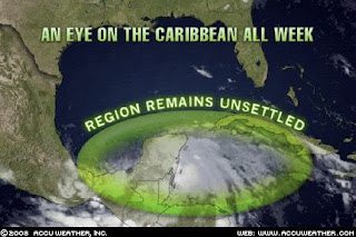

Thursday, May 29, 2008

And we're off to the races with ALMA

Tropical Storm Alma formed today right off the Nicaraguan coast as the first tropical system of 2008 in the eastern Pacfic. The storm has already knocked out power and caused flooding in low lying areas. Initial concerns that Alma might strengthen to a hurricane did not come to pass.

The eastern Pacific is predicted to have a below normal activity level this year. That still amounts to between 11 and 16 named storms with 5 to 8 expected to become hurricanes according to Wikipedia.
Alma formed as a tropical wave earlier in the week and strengthened to a tropical storm this afternoon. She is making landfall this evening and is expected to weaken significantly as she travels across Central America.


Storm Watch with: Rosemary's Thoughts, Alabama Improper, 123beta, DragonLady's World, Cao's Blog, The Amboy Times, Big Dog's Weblog, Democrat=Socialist, Conservative Cat, Pet's Garden Blog, Allie is Wired, third world county, Faultline USA, Online Gym, Alabama Improper, Woman Honor Thyself, The World According to Carl, The Pink Flamingo, Chucjk's Place, , Right Voices, and The Yankee Sailor, thanks to Linkfest Haven Deluxe.

Thursday, May 22, 2008

New method for measuring hurricane strength

Hurricane hunter aircraft are invaluable to measuring the intensity of a hurricane or strong tropical storm. The problem is that each flight is very expensive and quite dangerous. Congress eliminated the program in the Pacific and had eliminatd it in the Atlantic only to reinstate it when public outcry became too great.

Due to the high costs involved, only storms approaching the US get monitored in this way. Many storms in the Atlantic and all of the storms in the Pacific (where storms are more prevalent) go unmonitored, relying on satellite measurements for determination of intensity.

A new method, one that provides the data at a fraction of the cost and far less risk, can create a method to monitor all storms over the entire planet.

Nicholas Makris, associate professor of mechanical and ocean engineering and director of MIT's Laboratory for Undersea Remote Sensing, thinks there may be a better way. By placing hydrophones (underwater microphones) deep below the surface in the path of an oncoming hurricane, it's possible to measure wind power as a function of the intensity of the sound. The roiling action of the wind, churning up waves and turning the water into a bubble-filled froth, causes a rushing sound whose volume is a direct indicator of the storm's destructive power.

Satellite monitoring is good at showing the track of a hurricane, Makris says, but not as reliable as aircraft in determining destructive power.

The current warning systems are estimated to save $2.5 billion a year in the United States, and improved systems could save even more, he says. And since many parts of the world that are subject to devastating cyclones cannot afford the cost of hurricane-monitoring aircraft, the potential for saving lives and preventing devastating damage is even greater elsewhere.


Such a system can be deployed in the storm path ahead of a storm and can be set up in a grid pattern in especially prone areas such as the eastern Pacific or the Carribean Sea to have a permanent monitoring system in place. Such a system will also be able to detect sudden increases or decreases in intensity as a storm approaches land. The recent cyclone in Myanmar intensified suddenly and drastically as it made landfall while Katrina dropped significantly from a level 5 to a level 3 before she came ashore in Mississippi and Louisiana. Having this data cane help public service officials make better decisions before and during an evacuation.

Tuesday, May 06, 2008

Cyclone Nargis rips through Myanmar

UPDATE #3 (7 May 2008): Burma cyclone: Secretive junta 'is holding up aid efforts and hiding death toll set to top 60,000' From the Daily Mail. This article has a bunch of pictures showing the devastation. I am learning that India provided as much as 2 days notice that this was going to be a bad storm and what the pathway was and the military government of Myanmar (Burma) did not notify the people. There is also conflicting reports as to whether the UN relief workers have been allowed n. To my knowledge the Myanmar government still has not allowed US access to assess the situation or assist even though we have asked repeatedly.

UPDATE #2 (6 May 2008): Aid workers fear Burma cyclone deaths will top 50,000

Silent video of the devastation

The official death toll as of Tuesday morning is 15,000 dead and over 30,000 missing. These number continue to climb as more information is received from the devastated area. This disaster is on the same order of magnitude as was the tsunami of 2004.

Foreign aid workers in Burma have concluded that as many as 50,000 people died in Saturday’s cyclone, and two to three million are homeless, in a disaster whose scale invites comparison with the 2004 Indian Ocean tsunami. The official death count after Cyclone Nargis is 15,000, and the Thai Foreign Minister says he has been told that 30,000 people are missing. But due to the incompleteness of the information from the stricken Irrawaddy delta, UN and charity workers in the city of Rangoon privately believe that the number will eventually be several times higher.

Andrew Kirkwood, country director of the British charity Save The Children told The Times: “I’d characterise it as unprecedented in the history of Myanmar and on an order of magnitude with the effect of the tsunami on individual countries. It might well be more dead than the tsunami caused in Sri Lanka.”


Additionally, as many as 2 - 3 million people are homeless and in some towns as much as 95% of the infrastructure has been destroyed.

UPDATE: The estimates of loss of life continue to grow. The UN has been granted access by the military government and is rushing aid to the devastated country.

Myanmar believes 13,000 dead, missing from cyclone


YANGON (Reuters) - Myanmar's military junta believes at least 10,000 people died in a cyclone that ripped through the Irrawaddy delta, triggering a massive international aid response for the pariah state in southeast Asia.
"The basic message was that they believe the provisional death toll was about 10,000 with 3,000 missing," a Yangon-based diplomat told Reuters in Bangkok, summarizing a briefing from Foreign Minister Nyan Win. "It's a very serious toll."
The scale of the disaster from Saturday's devastating cyclone drew a rare acceptance of outside help from the diplomatically isolated generals, who spurned such approaches in the aftermath of the 2004 Indian Ocean tsunami.

snip..

The official toll on state media stands at 3,394 dead and 2,879 missing, although
those figures only cover two of the five declared disaster zones, where U.N. officials say hundreds of thousands are without shelter or drinking water.
The casualty count has been rising quickly as authorities reach hard-hit islands and villages in the Irrawaddy delta, the former "rice bowl of Asia" which bore the brunt of Cyclone Nargis's 190 km (120 miles) per hour winds.

Cyclone plunges Myanmar into primitive existence

May 5 (Reuters) -
Here are the latest developments on Monday following Saturday's devastating Cyclone Nargis in Myanmar
.


HEADLINES

- 3,934 killed, 41 injured and 2,879 missing within the Yangon
and Irrawaddy divisions, says Myanmar TV. The death toll is expected to rise as
it only covers two of the five disaster zones.

- U.N. says Myanmar
accepts international aid offers, shipments being prepared at once. U.N. says
hundreds of thousands of people are without shelter and drinking water.

- Soldiers and police kill 36 prisoners after riot at Yangon's notorious
Insein prison in chaos following cyclone, Thailand-based human rights group
says.

- Cyclone was a Category 3 storm, with winds of 190 kph (120 mph).

- Junta leaders say they will go ahead with May 10 referendum on a new
army-drafted constitution that critics say will entrench the military.
Nargis hit Myanmar as a dangerous Category 3 cyclone. Government estimates are that as many as 10,000 people may die as a result of this storm. As of this morning close to 4,000 are dead with as many as 3,000 missing.

According to GDACS over 7 million people can be affected by hurricane force winds with just under 2 million living in low lying coastal areas (elevations below 5 meters).


Linkfest Haven, the Blogger's Oasis

Storm Watch with:
Rosemary's Thoughts, 123beta, Right Truth, Kodera's Korner, DragonLady's World, The Amboy Times, Cao's Blog, Big Dog's Weblog, , Democrat=Socialist, Conservative Cat, third world county, Nuke Gingrich, Faultline USA, McCain Blogs, The World According to Carl, Pirate's Cove, The Pink Flamingo, Dumb Ox Daily News, , Right Voices, Stageleft, and The Yankee Sailor, thanks to Linkfest Haven Deluxe.

2010 Atlantic Hurricanes (courtesy of Weatherstreet.com)

NOAA Gulf of Mexico Radar (courtesy of Weatherstreet.com)

NOAA West Atlantic & Caribbean Radar (courtesy of Weatherstreet.com)

NOAA East Atlantic Radar (courtesy of Weatherstreet.com)