Gulf Coast Hurricane Tracker

A single source reference on tropical weather predictions. With a traditional focus on the upper Texas and Louisiana Gulf Coast we've maintained links to track all Atlantic Basin, Caribbean and eastern Pacific storm systems. We are now expanding our view to tropical storms throughout the world intending to be a comprehensive global storm tracking resource.

Thursday, September 28, 2006

Tropical Storm Issac following the pack

TD #9 has formed into Tropical Storm Issac. Once again we have a storm in the central Atlantic that will follow the same pathways away from the east coast of North America and head towards the northern areas of the oceans and possibly Europe.

The front off the east coast has done a fine job keeping storms away from land. Four storms have now followed or will follow the same track in the ocean and away from land.

Looking at the projected storm track, it looks like Bermuda may feel the effects of this storm, but it is not expected to reach hurricane status so the effects will not be as bad as they were with Florence.

Monday, September 25, 2006

Tropics are quiet worldwide

From The Weather Channel (link above), some really good news right in the middle of hurricane season:


Except for a couple of disturbed areas in the eastern Atlantic Ocean, the tropics are quiet. One disturbed area is located about 1100 miles east of the northern Windward Islands, but conditions there are not particularly favorable for the development of a depression.

The other area of interest is several hundred miles SSW of the Cape Verde Islands. Some additional development is possible there, and a depression could form within the next day or two as the system pushes westward.

There are no threats in the eastern Pacific.

Update: Well that was short lived. A few hours after this notice was posted at the Weather Channel, some tropical disturbances developed in the western Pacific and now TD#9 has formed and will soon become a tropical storm. It is still significant that the season is nowhere near as bad as last year was and is even much calmer than the predictions led us to believe. This is good.


Sunday, September 17, 2006

Moisture from Lane makes for strong storms over South Texas

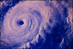
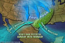
Hurricane Lane slammed into the western Mexican coast at Mazatlan as a Category 3. The storm quickly degenerated and is now only a tropical depression. The moisture from Lane is being carried into south Texas and is interacting with a fairly strong cold front resulting in some very heavy thunderstorms over southeast Texas and southwest Louisiana. Tropical moisture moving onshore from the Gulf adds additional moisture resulting in high humidity and fueling the storms with plenty of moisture.

Heavy rain is possible throughout Sunday night and all day Monday and Monday evening. Many areas in central Texas that have been under severe drought warnings are now under flood watches as too much rain is falling at once.

Lane began by following the storm path of Hurricane John which had caused a great deal of destruction along Baja California. As the storm strengthened, it turned eastward and came ashore into the mainland area of Mexico at Mazatlan.

Forming right alongside Lane is Tropical Storm Miriam. It looks like Miriam will avoid land and is expected to weaken fairly quickly.

In the Atlantic, it is looking like there will be a One-two-three striker with Hurricanes Gordon and Helene essentially following the same pathway as Hurricane Florence. Fortunately, Gordon missed the island altogether and I certainly hope the same happens with Helene.

I have been suspecting that Hurricane Helene will continue its predicted turn towards the north and will pass by Bermuda. However, the predictions continue to move the cone of uncertainty to the west and now the chance of at least tropical storm strength winds affecting Bermuda seems more likely. Helene is a Category 2 storm right now and may continue to strengthen. If strengthening continues and the predicted path continues to shift westward, Bermuda may be affected by a severe hurricane. We will have to keep a close eye on Helene now where earlier in the week it seemed as if both Gordon and Helen would be a concern only to shipping lanes. Now it seems as if that is not necessarily the case.

Gordon became the first storm of the year to reach a severe storm status (Cat 3) but quickly weakened in the cooler waters. The same scenario is expected for Helene but if the storms path brings it really close to Bermuda then the situation could change significantly.

Monday, September 11, 2006

September 11 Tribute

John J. Tobin
Age: 47
Killed at: World Trade Center
From: Kenilworth, NJ


From NY Newsday October 2001:
His office was in Midtown Manhattan, but on Sept. 11, John J. Tobin had to attend a meeting downtown. There, Tobin, 47, of Kenilworth, N.J., lost his life when an act of terrorism shook the Manhattan skyline.

Though an accomplished businessman, Tobin, a senior vice president of the Finpro division of Marsh & McLennan, made no airs about his success, his wife of 24 years told the Newark Star-Ledger.

“He treated everybody the same,” said Barbara Tobin. “You wouldn’t know the kind of job he had. He didn’t drive a Lexus or wear a Rolex. He didn’t need material things.”

His wife and family, which included children Sean, 11, and Jennifer, 19, were at the center of Tobin’s life. Despite a demanding career, explained his wife, he spent his free time coaching Sean’s Little League team, helping his kids with their schoolwork, and being involved with their activities. “He pushed the kids to be the best they could be,” she said.

Tobin is also survived by his sister Margaret, brother Michael, sister-in-law Kathleen, and two nieces.
-- Jenna Kern (For
Newsday)
As part of the 2996 Project, we the readers and authors of Gulf Coast Hurricane Tracker honor John J. Tobin and all those who were so cruelly taken from us on that fateful day. May the grace of Almighty God be bestowed on his soul and may his family find peace and comfort.

Saturday, September 09, 2006

Bermuda prepares for a hurricane

Tropical storm Florence has strengthened to a hurricane. As of Sunday morning the sustained wind speed was up to 80 mph. The storm's direction has also begun it's long expected turn to the north. By Monday Florence will be heading about due north and is expected to reach Bermuda at hurricane strength. It is likely that she will be a Cat 2 hurricane by the time it makes landfall.

The good news, if there can be such a thing with an impending hurricane is that of all the areas at risk of a storm, Bermuda is probably the best prepared with a building code that requires all new buildings be able to withstand a minimum of 110 mph winds. The island also has many of its phone and utility lines underground adding to the stability of its infrastructure. Let's all hope and pray that any damage is limited and that everyone on the island remains safe.

Wednesday, September 06, 2006

Tropical Storm (Hurricane) Florence Advisory

Both the National Hurricane Center and the US Navy are showing that the path of Tropical Storm Florence is likely to turn north over the weekend. More of the computer models are also predicting a northward turn although some of them are still predicting the storm heading towards the coast.


It is looking more and more like all of the forecasts are predicting a northward turn later in the week.

Florence continues to strengthen and is expected to reach hurricane status by the end of the week. Increases in strength may continue for quite awhile until the storm moves far enough north that the water temperature is too cool to sustain a severe storm.

From The Weather Channel :

Despite wind shear from an upper low to the west of Tropical Storm Florence, the system has strengthened some today with top sustained winds of 50 mph as of 5 p.m. EDT. The shear will continue to diminish over the next couple of days, so Florence could very well become a hurricane a couple of hundred miles northeast of the northern Leeward Islands by Friday morning. A
gradual turn by Florence toward the north is expected over the weekend
, so the hurricane should miss the U. S. but threaten Bermuda. Florence may also become the first major hurricane of the year this weekend.

Closer to the U.S., Hurricane Hunters are investigating an area of disturbed weather off the Southeast Coast. This system has a small window to develop before interacting with a frontal boundary. Farther out in the Atlantic, a disturbance trailing Florence by several hundred miles has some potential for further development over the next day or two. A third disturbance, well south of the Cape Verde Islands, also bears watching. A sharp wave has developed at the surface in the east-central Caribbean Sea. Thunderstorms have flared up during the past 6-12 hours south of Hispaniola. If they persist for another 12 hours we may see a weak low pressure center form as the wave drifts west at about 10 mph.

In the eastern Pacific, tenacious Kristy (35 mph) has been downgraded to a tropical depression.


We will update this post as new information becomes available.

Tuesday, September 05, 2006

TD #6 becomes Tropical Storm Florence


The 6th named storm of the season formed in the Atlantic this morning. Tropical storm Florence is expected to strengthen and become a hurricane within a couple of days. The area of the North Atlantic where the storm is now has a good deal of wind shear so the potential for further organization is likely low for a couple of days. By the end of the week, Florence should be a Cat. 1 hurricane.

On its current projected pathway, the storm is heading for the southeast US coast and may even strengthen, but it is way to early to predict landfall. Most of the computer models are predicting that the storm will actually turn north and possibly stay away from land. Again, it is really too early to tell which way the storm will head as it gets closer to land. Next weekend will provide us with a more accurate forecast of both direction and intensity.


It is important to note that right now (Tuesday evening), a tropical wave is located further east of Florence and could develop into a tropical depression over the next few days. September is the month where we will typically see storms steadily flow off the wester coast of Africa and develop as they move across the ocean. Dr. William Gray of Colorado State is predicting that September will see as many storms as we have had so far all season (see earlier post). We will have to keep an eye out across the Atlantic to see how things develop.

Sunday, September 03, 2006

August Tropical Wrapup

Well after expecting a very active hurricane season, so far we have been treated to very few storms. So few, in fact, that the weather forecasters have reduced the predicted number of storms twice.

Experts Lower Hurricane Forecast to 5

This is certainly no time to relax and count our bessings. We are now in the midst of the busiest time of the year for tropical activity so more storms are likely to form. And, of course, it only takes one direct hit on whatever location you are at to be a bad season.

However, NOAA Continues to Predict Above Normal Hurricane Season. We are still in the early years of the Atlantic Multidecadal Cycle when a higher than average number of storms is expected, so even if the actual number of is reduced once again, it is still a good bet that September and October will be busy months.

With thanks to: NOAA Released August 8, 2006
We ended August with 3 active system - Ernesto, John and Kristy - but only Ernesto affected the Atlantic. Ernesto was the first storm this year to become a hurricane and fortuanely it was only a Catagory 1 storm before it broke down and remained a tropical storm. Twice the prediction was for the storm to re-strengthen to a hurricane but its forward movement resulted in interaction with land before sufficient strength could be achieved.

In the Pacific, John came to our attention as a Catagory 4 monster and steadily dwindled in strength. Heavy waves, wind and rain battered the western Mexican coast quite a bit but the real concern was that it would cross Baja California at full strength. Fortunatley by the time the storm reached Baja it was only a Cat 1 and quickly weakened to a tropical storm. Now the storm center is crossing along the length of the peninsula which would have certainly been a disaster if the storm strength was anywhere near its original level.

John and tropical storm Kristy are headed for cooler waters so we shouldn't hear much more about either storm.

Trackbacked to: Dumb Ox News, Woman Honor Thyself, 123Beta

Friday, September 01, 2006

Ernesto Advisory

Ernesto Soaks Virginia, Carolinas
Wet Weather Not Stopping Holiday Travelers
Washington, DC Radar
State College, PA Radar

As the graphics show, the remnants of Tropical Storm Ernesto, now a tropical depression, are moving northward across the Carolinas and into Virginia. The storm track is expected to take it into Pennsylvania and eventually New York State throught the weekend. This si an area of the country that certainly has had an abundance of rain this summer so flooding will be a major concern. We will maintain coverage throughout the weekend and onward until the NWS discontinues alerts.


Ernesto is now back to a tropical storm. Looks like the mountains of Haiti did their thing in breaking down the hurricane. Stregnthening may occur once the storm emerges over water but will again be broken down once it contacts land again in Cuba.

Computer models continue to adjust the presictions for landfall further east after the storm enters the Gulf. Landfall in western Florida now seems to be the likly path. Each time I look at the predictions, the models move the storm's path further east.


To show how quickly situations can change, yesterday we were predicting that Ernesto could become a dangerous Gulf hurricane. Now Fox News is reporting that the storm's path is taking the storm over mountainous land as the storm crosses or passes Cuba. This is likly to lessen the intensity of the storm and could lead towards dissipation. So right now the storms strength at landfall is very unpredictable.
The concern is, of course, that the warm waters of the Gulf will cause Ernesto to strengthen and may cause damage to the oil platforms and potentially threaten New Orleans, Louisiana and Mississippi coasts. As the graphic shows, the computer models are already predicting a turn towards Florida after the storm enters the Gulf. Of course this far out and the accuracy of the models is questionable. People in Mississippi, Alabama and Louisiana need to keep a vigilant watch at least into mid week.

Trackback Linking now available

Hey friends... I just want to let everyone know that I've just gone ahead and added trackback capabilities. Right now I plan to keep it open so trackback as much as you want. Let's see how well networled we can be. Only a few basic rules:

1. NO PORN
2. No foul language
3. Don't link to commercial advertisement sites
4. NO PORN!!

Thanks y'all.

PS> Unfortunately, all previous comments have been lost. That was one of the reasons I was tryign to not switch to Haloscan but the process for adding just the Trackback option was too complicated for me.

commenting and trackback have been added to this blog.

2010 Atlantic Hurricanes (courtesy of Weatherstreet.com)

NOAA Gulf of Mexico Radar (courtesy of Weatherstreet.com)

NOAA West Atlantic & Caribbean Radar (courtesy of Weatherstreet.com)

NOAA East Atlantic Radar (courtesy of Weatherstreet.com)