Gulf Coast Hurricane Tracker

A single source reference on tropical weather predictions. With a traditional focus on the upper Texas and Louisiana Gulf Coast we've maintained links to track all Atlantic Basin, Caribbean and eastern Pacific storm systems. We are now expanding our view to tropical storms throughout the world intending to be a comprehensive global storm tracking resource.

Sunday, February 28, 2010

Tsunamis traverse Pacific Ocean

The epicenter of the Chilean earthquake was located 70 miles off the coast generating a string of tsunamis that eminated from the coast across the entire Pacific Ocean. Tsunami warnings were issued along the coasts of North and South America, New Zealand, Australia, Japan and Russia. Hawaii, Tonga, Samoa and many other Pacific Islands also issued tsunami warnings.


Chart of the Chile tsunami's travel time, released by the National Atmospheric and Oceanic Administration. Photograph: AFP/Getty Images (Courtesy of guardian.co.uk)

Fortunately, most of these warnings proved to be non-events. Waves averaging just under 1/2 meter (1.44 ft) came ashore with the smallest waves of 0.04 m (0.1 ft) reaching the shore at Tonga and the waves of 1.79 m (5.9 ft) reaching French Polynesia.

Since the epicenter of the quake was located off-shore, some of the highest waves pushed back onto the Chilean shore. Wave heights of 1.29 meters (4.2 ft) were recorded in Valparaiso, 1.32 meters (4.3 ft) in Coquimbo and 2.34 meters (7.7 ft) in Talcahuano. While most regions around the Pacific Rim had warning times that could be measured in several hours to 1/2 - 3/4 of a day, Chile only had minutes from the earthquake before the tsunami waves sloshed ashore.

Source: Chile earthquake: where the tsunami struck (The Guardian)

The devastating earthquake that has struck Chile also caused a string of tsunamis across the region.

Although the tsunamis weren't as strong as first feared, they also caused deaths and destruction: as many as 350 people had died in one Chilean coastal town, Constitución, which was hit first by the earthquake and then by a tsunami.

Massive earthquake strikes Chile

A magnitude 8.8 earthquake struck coastal Chile Saturday a few hours before daybreak. Sine then a series of several aftershocks shook the area including one very strong 6.9 magnitude aftershock.

Chile Earthquake 2010 (Puggal)

The origin of the earthquake was at a depth of 22 miles and was centered about 200 miles southwest of Santiago. This earthquake of 27 February, 2010 is declared as the most powerful quake in last 100 years and also compared with the strongest earthquake of Ecuador.
Throughout the day Saturday, the death toll remained fairly steady around 300 -400 people. This morning the death toll jumped to over 700 people. As rescue operations are continuing, it is possible that even more bodies will be discovered. Hopefully, many more survivors will also be found and rescued.

Chilean quake toll jumps to 708 (BBC News)

The death toll from Chile's earthquake has more than doubled to 708 and is expected to rise further, President Michelle Bachelet has said.

Previously about 300 people were reported to have been killed in Saturday's 8.8 magnitude quake - one of the most powerful recorded.

Massive damage is hampering rescue teams as they struggle to reach those still buried in the rubble.

However a Pacific-wide alert for a tsunami has been lifted.

Speaking to reporters on Sunday, Ms Bachelet said: "The catastrophe is enormous. The latest number I have is 708 dead."

She said 541 had died in Maule region, 64 in Biobio and a total of 103 in other areas. She added that the number of people missing was growing.

Earlier, President Bachelet said two million people had been affected by the earthquake.

Chile needs much help right now. The article at the link below has information on how to reach the following aide organizations:

Chile's Earthquake 2010: How to Help Survivors (Heath & Wellness)

Doctors Without Borders

Americares

International Rescue Committee

Catholic Relief Services

TEXT a Donation - Sending a donation via text is a fast and easy way to help the earthquake survivors in Chile. Each dollar helps tremendously as aid groups struggle to help the millions of people displaced by the earthquake.

  • SALVATION ARMY: Text CHILE to 52000 to give $10.
  • RED CROSS: Text CHILE to 90999 to give $10.
  • WORLD VISION: Text CHILE to 20222 to give $10
  • HABITAT FOR HUMANITY: Text CHILE to 23583 to give $10
Fortunately the situation is not a dire as it is in Haiti. Haiti's earthquake last month was a 7.0 magnitude earthquake which was absolutely devastating. Chile is seismically active being located along the geologically active Ring of Fire so the Chileans enforce stringent building codes to address earthquakes and their economy is much more robust than Haiti's.

In addition to the poverty of Haiti, their earthquake, while weaker, hit right in the very populous capital while Chile's was located further from the cities.

Chile and Haiti: A Tale of Two Earthquakes (Time)
The 8.8-magnitude earthquake that hit Chile early on Feb. 27 was 500 times stronger than the 7.0 quake that killed an estimated 200,000 Haitians last month. And yet the number of casualties in Chile appears to be exponentially smaller, with the official death toll still in the hundreds. Far fewer people were rendered homeless than in Haiti, and much of the telephone service in Santiago and parts of central Chile had been restored within five hours.

Saturday, February 20, 2010

Tropical cyclone Gelane passing Rodrigues; weakening

Intense tropical cyclone Gelane appears to have weakened slightly from a Category 4 to a Category 3 on the Saffir-Simpson Scale. It is still a major tropical cyclone. Rodrigues remains on a Class II alert indicating that the potential for danger still exists for the next 12 hours.

Tropical Storm Risk is reporting the potential for tropical storm force winds in Port Mathurin today.

A Class I alert exists on the Island of Maurice but it is unlikely that any significant effects of the storm will be felt there as Gelane is 430 km away from Maurice.


Gélane qui s'affaiblit, est à 430 km de l'île Maurice (Zinfos 974)

Le dernier point publié par Météo Maurice sur son site internet, situe à 10 heure, heure de l'île Maurice, le cyclone tropical Gélane par 18.8 Sud et 61.8 Est. Cette masse se déplace qui s'est affaiblie, se déplace pour les météorologues mauriciens à 8 km/h. L'île Maurice n'est pas encore passée en alerte 1. Les prévisions demeurent identiques à celles de ce matin.

English Translation Courtesy of Google Translate


The equivalent of a tropical storm watch has been issued for Reunion in anticipation of the approach of this storm.

Cyclone Gélane: Alerte sur Rodrigues, pré-alerte cyclonique à la Réunion (Meteo World)

Le cyclone Gélane a perdu légèrement de son intensité cette nuit. Il se rapproche de l’île Maurice qui pourrait bientôt passer en alerte de niveau 1/4, l’île de Rodrigues voit son niveau d’alerte s’élever d’un cran et passe en alerte de niveau 2/4 ce matin, ce qui signifie qu’un danger existe dans les 12
prochaines heures.

L’île de la Réunion a été placée quant à elle en préalerte cyclonique, ce qui signifie une menace potentielle dans les prochains jours au-delà de 24h00.

Au dernier bulletin de 3h00 GMT, le centre du cyclone de catégorie 3/5 était localisé à environ 472 km au Nord-Est de Port-Louis (île Maurice) et plus de 600 km des côtes Réunionnaises.Il se déplaçait vers le Sud-Ouest à la vitesse moyenne de 11 km/h.Les vents soufflaient à 194 km/h en moyenne et jusqu’à 240 km/h en rafale.

English Translation Courtesy of Google Translate

Meteo France is reporting that with the exception of Rodrigues, there is essentially no threat to any other land for the next 24 hours.

Gélane à 655 km de La Réunion, “ne présente pas de menace dans les prochaines 24 heures” (Zinfos 974)

Météo France a effectué son dernier point de la situation à 10 heures de La Réunion. Le cyclone tropical Gélane était alors situé par 18.6 Sud et 61.5. La Réunion reste en pré-alerte cyclonique.

Le phénomène naturel était à 655 km dans l'Est - Nord-Est de notre île à 10 heures. Il se déplace en direction du Sud - Sud-Ouest, à 9 km/h. Et selon le centre météorologique du Chaudron, Gélane “ne présente pas de menace pour les prochaines vingt-quatre heures”.

English Translation Courtesy of Google Translate

Friday, February 19, 2010

Very Intense Cyclone Gelane heads to Rodrigues

At 9:30 am Friday February 19th, the island of Rodrigues declared a Level I alert as Tropical Cyclone Gelane approached with 10 minute average windspeeds of 130 km/hr and gusts as high as 180 km/hr. Gelane was heading to the south at 10 km/hr. Gelane had initially diminished slightly Thursday before significantly gaining intensity a day later.

Cyclone Gelane: Rodrigues passe en alerte 1 (Lexpress.mu)

La station météorologique de Vacoas a placé Rodrigues en alerte 1 suite au rapprochement du cyclone Gelane, qui se trouve à 340 km de l’île se déplaçant à une vitesse de 10 km/h.

Rodrigues en alerte Un. A 9h30, ce vendredi 19 février, le cyclone tropical Gelane était situé à 340 km de Rodrigues. Le Cyclone se déplace à une vitesse de 10 km/h en direction du Sud. La pression estimée au centre : 975 hectopascals, vents moyens sur dix minutes de 130 km/h, rafales de 180 km/h.

Après s’être affaibli, rétrogradé provisoirement en forte tempête tropicale le 17 février, Gelane a retrouvé son statut de cyclone tropical hier après-midi, 18 février, et se rapproche de Rodrigues et de Maurice.

English Translation courtesy Google Translate


By 22:00 hrs Rodrigues had upgraded the alert to a level II. Gelane had grown to a Category 4 cyclone on the Saffir-Simson Scale with maximum windspeeds of 143 MPH/231 km/hr and is now classified a Very Intense Tropical Cyclone. A 10 km diameter eye has been detected by NASA's Aqua satellite.

Small and mighty cyclone Gelane reaches category 4 strength (Physorg)
The or MODIS instrument on NASA's Aqua satellite caught an impressive visible image of Gelane on February 19 at 09:45 UTC (4:45 a.m. ET) that clearly showed the eye of this Category 4 . Additionally, animated multispectral indicates a small 10 nautical mile-round eye. Satellite imagery also helped forecasters determine that the diameter of the storm is about 120-150 nautical miles in diameter.

At this time, Gelane's center remains in the open waters of the Southern Indian Ocean and it is a small storm so hurricane-force winds are not reaching any land areas. At 10 a.m. ET (15:00 UTC) on Friday, February 19, Gelane was 315 miles east-northeast of Port Louis, Mauritius, near 17.3 South and 62.1 East. It had near 125 knots (143 mph/231 kph). Hurricane-force winds extended to about 30 miles from the center, while tropical-storm force winds extended 85 miles from the center. The storm is kicking up 29-foot high waves in the open ocean, but residents in nearby Port Louis and Reunion Island will experience rough surf over the weekend as the center of Gelane passes to their east-southeast.

Rodrigues passe en Alerte II (Grandbaie.mu)

Dernière heure, Classe II toujours en vigeur à 22 heures.. La station météorologique de Vacoas a émis un avertissement de cyclone de classe 2 pour l'ile Rodrigues à 16h00. Le cyclone Gelane a continué son déplacement vers le sud et constitue un danger potentiel pour l'ile par son rapprochement.

Selon le tout dernier communiqué, la météo mauricienne maintient un avertissement de classe II sur Rodriques car Gelane était à 22 heures à 240 kilometres de Rodrigues soit au point 18.O Sud et 62.0 Est. Il se dirigeait vers le sud à une vitesse 10 kilometres par heures.

Mais dans ce meme bulletin il est fait mention de notre analyse de jeudi que le cyclone tournerai vers le sud-sud ouest ce que confirme la météo mauricienne. Donc le cyclone tropical intense se dirige vers la région de Maurice.

A 15h30 le cyclone Gelane était pointé à 280 kilomètres de Rodrigues, soit au point 17.4 Sud et 16.2 Est. La vitesse de déplacement était vers le sud durant les dernières sept heures de 10 kilomètres par heure. L'information majeur est que durant la journée le cyclone tropical s'est encore intensifiée en un cyclone tropical intense avec des rafales de 225 kilomètres avec une pression qui est descendu à 930 hpa, le classant dans la catégorie 6.5 dans l'échelle dvorak.

English Translation courtesy of Google Translate

Monday, February 15, 2010

Fwd: TSR Storm Alert - Tropical Cyclone RENE

Tropical Cyclone Rene made landfall on Tonga earlier Monday with wind gusts as high as 228 km/hr and sustained winds of nearly 170 km/hr making Rene a Category 4 cyclone.
Tropical Cyclone Rene, which has been upgraded to a category 4 storm, hit Vava'u and Ha'apai islands in the north of Tonga early Monday.

The storm was carrying winds of nearly 170 km an hour close to its center.

Chief Inspector Toia, who was in the capital Nuku'alofa, said she had spoken to colleagues on both islands who told her there was already damage to trees and crops, Radio New Zealand International reported.

Flooding was expected in coastal areas and people there had been told to move to higher ground.
NUKU'ALOFA, Tonga — Cyclone Rene battered Tonga with powerful winds Monday, cutting phone links, ripping off roofs and downing power lines in the South Pacific island nation.
All telephone links with the outside world went down as the storm pounded the capital, Nuku'alofa, on the main island of Tongatapu in the south of the kingdom.
 
Prior to losing contact, there were no reports of casualties or severe damage, but the Ha'apai island group, located in the center of the archipelago, faced "very destructive hurricane force winds" with gusts of 143 miles (228 kilometers) an hour, the Meteorological Office said. Heavy rain, thunderstorms, sea swells and flooding were expected.
 
--snip--
 
Tonga, the South Pacific's last kingdom, has a population of 101,000.
 
The storm missed both American Samoa, a U.S. territory, and the neighboring island nation of Samoa on Saturday, though it triggered heavy rains, high winds and large sea swells. Both areas were spared more devastation after being battered by a tsunami that killed 226 people last year.
 
American Samoa Gov. Togiola Tulafono said a preliminary report indicated minimal damage to homes and government property from the storm, which indirectly caused one death — a 50-year-old man who fell from a two-story apartment building while trying to board it up Friday.
SW Pacific: Storm Alert issued at 15 Feb, 2010 6:00 GMT
 
Tropical Cyclone RENE (15P) is forecast to strike land to the following likelihood(s) at the given lead time(s):
Red Alert City(s) and Town(s)
    Nuku' alofa (21.1 S, 175.2 W)
        probability for CAT 1 or above is 95% within 12 hours
        probability for TS is 85% currently

Note that
    Red Alert (Severe) is CAT 1 or above to between 31% and 100% probability.
    CAT 1 means Tropical Cyclone strength winds of at least 74 mph, 119 km/h or 64 knots 1-min sustained.
    TS means Tropical Storm strength winds of at least 39 mph, 63 km/h or 34 knots 1-min sustained.

For graphical forecast information and further details please visit http://www.tropicalstormrisk.com/

This alert is provided by Tropical Storm Risk (TSR) which is sponsored by UCL, Aon Benfield, Royal & SunAlliance, Crawford & Company and Aon Benfield UCL Hazard Research Centre. TSR acknowledges the support of the UK Met Office.

Thursday, February 11, 2010

Two tropical cyclone form in the South Pacific

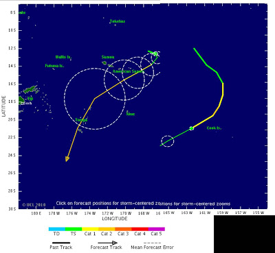
Graphic pasted trom two separate graphics courtesy of Tropical Storm Risk (2/11/10).


Two tropical cyclones are active in the South Pacific.

Tropical cyclone Pat developed Wednesday and grew from tropical storm status to essentially a Category 1 hurricane or typhoon on the Stafford Simpson Scale as shown in the graphic above. The scale for the southern hemisphere is different, these windspeeds would make Pat a Category 3 cyclone.

Cyclone Pat hit the Cook Islands causing damage to homes and trees, bringing down power lines. The main island of Rarotonga was spared of major damage but the smaller island of Aitutaki was essentially destroyed with around 90% of homes on the island destroyed. Fortunately there do not appear to be any injuries or deaths.

Tropical cyclone hits Cook Islands, no injuries (China Post)

A tropical cyclone smashed houses, trees and power lines as it cut a swath through the Cook Islands in the South Pacific, officials said Thursday.

Cyclone Pat spared the main island of Rarotonga but was one of the biggest storms to hit the low-lying coral atoll of Aitutaki in about 20 years, damaging 90 percent of the houses on the island of 2,000 people, said Inspector Teri Pati of the National Disaster Management Center on Rarotonga.

There were no initial reports of deaths or injuries from the storm, which struck late Wednesday, though injuries were likely, he said.

The government declared an emergency on Aitutaki, a move to help with recovery and repairs and likely to also attract assistance from nearby New Zealand.

"It's one of the worst cyclones to have struck the island just judging by the reported damage," Pati told New Zealand's National Radio.


Tropical Cyclone Pat is dissipating and is expected to be non-existant within 24 - 48 hours.

A day later Tropical cyclone Rene formed in about the same area. Rene is tracking towards Samoa and American Samoa and is expected to strengthen to around a Category 3 cyclone as well.While Rene is further west than Pat, The Northern Cook Islands are expected to be hit by Rene just days after being pounded by Cyclone Pat.

Second cyclone set to hit Cook Islands (NZ Herald)
A second tropical cyclone is forecast to hit the Cook Islands after a State of Disaster has been declared on the island of Aitutaki.

The Fiji Meteorological Service is forecasting Cyclone Rene to hit Nassau, Pukapuka, Suwarrow and nearby islands with gale force winds.

Current windspeeds of 95 kphmake Rene a Category 2 cyclone which is heading towards the Lau Island Group as it intensifies.

Cyclone Rene will affect the Lau group (FBC)
People living in the Lau Group and surrounding areas have been warned to expect heavy swells and strong winds as Tropical Cyclone Rene continues to intensify between Samoa and Tonga.

The Nadi weather office says Tropical Cyclone Rene’s projected path is still uncertain, but could affect the Lau Group and other places.

Tropical Cyclone Rene is presently a Category 2 cyclone and has average winds of 95 kilometres. It is expected to intensify into a Category 3 status with in the next 24 hours.

New cyclone heads for Samoa (Stuff.co.nz)
A third cyclone in two weeks has formed north of Samoa and is expected to double back on itself and threaten tsunami damaged areas and Niue.

Cyclone Rene follows Cyclones Oli and Pat, which caused major damage and injury, but no deaths, on the Cook Islands and French Polynesia.

The Nadi Tropical Cyclone Centre says Rene is 130 kilometres southwest of Nassau Island and 170 kilometres south-southwest of Pukapuka in the northern Cook Islands.

The Honolulu Joint Typhoon Warning Centre says Rene is moving east but in the next couple of hours will sharply turn southwest toward Niue.

A wide area of the Pacific is under alert including the southern coasts of Samoa and American Samoa which were badly affected by last year's deadly tsunami.


Monday, February 08, 2010

Audi Superbowl commercial

Is this the real end-game for the environmental alarmists?


I think this is a great commercial and is quite funny. I applaud Audi for keeping a sense of humor and pointing to the extreme as a way to to get people's attention.

The question, though, is where are we headed environmentally?


We have made great progress since the 1970's with air pollution, litter and water pollution, but this does not seem to be enough. Yes we must take care of the environment but when people claim that clean, harmless CO2 is a pollutant and act hysterically whenever anyone tries to discuss a differing point of view, the result can lead to the video above.

Carbon dioxide along with water are the natural end products of complete combustion and respiration. as long as things burn or animals breathe, CO2 will be generated.

In 1859, John Tyndall isolated various gases in an apparatus and discovered the "greenhouse effect".

On the origin of ‘the greenhouse effect’: John Tyndall’s 1859 interrogation of nature (Wiley InterScience).

From what I can tell in the above article, the one thing Dr. Tyndall did not try was combining multiple gases to see the interactive effect. But carbon dioxide is only a very small portion of the atmosphere (388 ppm) while water vapor is anywhere from 2 - 6% depending on relative humidity. The increase in CO2 in the atmosphere is but a trace compared to the variability of moisture in the air and the effect of that moisture on heat entrapment. The effect of humidity is clear on a hot day in Houston or Miami compared with the same temperatures in Phoenix or Sacramento.

Likewise plastics have received a bum rap over the years. Yet the processes for producing plastics are much cleaner than the process for making paper products. Just drive by a paper mill and take a deep breath of the air down-wind. The stench can be unbearable and the water pollution can be quite serious as well (IMHO). Plastics plants are clean and do not contribute to air or water pollution provided that they maintain good housekeeping as required by law and good citizenship.

If we are not careful, green police and PC police will take away our liberties by eliminating the choices we can make for ourselves and our families.

Sunday, February 07, 2010

Tropical Cyclone Oli causes calamity

A state of calamity was called in French Polynesia after Tropical Cyclone Oli destroyed several hundred houses on the islands of Bora Bora, Tahiti and Tubuai.

State of calamity called in cyclone-hit French Polynesia (Radio Australia)
French Polynesia is getting back on its feet after being battered by one of the worst storm in years this weekend, but Radio Australia has just learned that a state of calamity has been called as damage assessments come in.

Cyclone Oli passed across the territory this weekend, destroying hundreds of homes in Bora Bora and Tahiti. However it was the island of Tubuai, in the Austral Islands that was the worst hit
Emergency supplies being rushed to French Polynesian island hit by Cyclone Oli (Radio New Zealand International)
An estimated 600 homes were destroyed in the French Polynesia when Cyclone Oli struck last week.

One person died when the cyclone crossed the islands bringing winds in excess of 200 kilometres an hour.

The immediate need on the island of Tubuai is to restore power and water supplies.

Oli developed into a very severe tropical cyclone with sustained winds of 130 MPH (210 km/hr). The storm tracked just south of much of the French Polynesian island chain but crossed over the islands of Rurutu and Tubuai as a Category 4 cyclone on February 4th. The above mentioned calamity reports are becoming apparent durign the clean-up in the aftermath of the storms.

Cat 4 Tropical Cyclone Oli Strikes French Polynesia; RMS Analysis (Insurance Journal)

At Noon local time (Feb 4th) the Joint Typhoon Warning Center (JTWC), estimated that Tropical Storm Oli's maximum sustained winds had reached approximately 130 mph (210 km/h), which would classify it as a category four hurricane.

--snip--

French television showed by now all too familiar pictures of towering waves - above 7 meters (22 feet) - breaking over large stretches of the islands. Palm trees were bent nearly to the ground and detached roofs were flying through the air.

--snip--

RMS reported. "The storm has brought strong winds, torrential rainfall and waves several meters in height to the Cook Islands, Bora Bora and Tahiti. More than 650 tourists trapped on Bora Bora have been relocated in other hotels. Schools in western Polynesia have been closed and people have been told to abandon primitive grass and mud dwellings and head to solid buildings such as town halls, schools or churches."

Reports of damages are now coming in, but sporadically. A number of buildings on Tahiti have been destroyed and many areas of the island are without power. Local authorities are in the process of evacuating low lying residents, following flooding initiated by the storm.

Saturday, February 06, 2010

A Forensic Analysis of Hurricane Katrina's Impact: Methods and Findings

Ocean Engineering is an international journal of research and development published by Elsevier. Elsevier provides high quality scientific content on line typically to subscribers or on a fee per article basis.

A special edition of Ocean Engineering is being provided free of charge for 1 year.

Volume 37, Issue 1, Pages 1-154 (January 2010)
A Forensic Analysis of Hurricane Katrina's Impact: Methods and Findings


Edited by Z. Demirbilek, D.T. Resio and R.G. Dean

I received an e-mail making me aware of this issue a few days ago. The table of contents of this edition is listed at the end of this post and the link above will bring you to the homepage for this issue complete with active links to either webpages or pdf format pages of each section of this report.


A recent special edition of Ocean Engineering provides an analysis of the impact of Hurricane Katrina, and an overview of the lessons learnt in the aftermath of the disaster.

Hurricane Katrina was the most destructive natural disaster in the US history. Katrina's size was larger than most hurricanes and its storm surge affected a larger area, nearly 93,000 square miles.

It was Hurricane Katrina and the subsequent sustained flooding of New Orleans that exposed significant flaws in Federal, State, and local preparedness for catastrophic events, requiring revision of emergency plans at all levels of government to coordinate and integrate State, local, and private sector partners.

Between September 2005 and September 2006, the Interagency Performance Evaluation Task (IPET) force study sought to evaluate the performance of flood protection systems following the devastation caused by Hurricane Katrina.

The aim of this Special Issue of Ocean Engineering is to disseminate key findings from research and engineering works conducted by the IPET task force to scientific and engineering communities worldwide.The ultimate goal is to help prepare for and
deal with potential consequences of severe hurricanes in the future.

You can access this special issue free online onScienceDirect for a year.

Yours sincerely,


Carrie Christensen


The next several posts will provide summaries of each section of this report. Many lessons can be learned from the response to Hurricane Katrina and the preparation or lack there-of.

It is easy to point to the many failures in government in the response to this powerful storm. We must also remember that New Orleans sits in a bowl below sea level protected by earthen levees. Such a scenario had been discussed several times in the past as a worst case scenario. The possibility of New Orleans flooding and filling up was and continues to be a very real possibility.

Federal, state and city officials must prepare for tropical weather and upgrade the protections around the city.

Table of Contents

1. Editorial Board

2. Introduction: Hurricane Katrina and Ocean Engineering lessons learned

Special Issue Papers:

3. The anatomy of a disaster, an overview of Hurricane Katrina and New Orleans

4. A review of climatological characteristics of landfalling Gulf hurricanes for wind, wave, and surge hazard estimation.

5. Reconstruction of Hurricane Katrina's wind fields for storm surge and wave hindcasting

6. Potential impact of sea level rise on coastal surges in southeast Louisiana

7. Physical model study of wave and current conditions at 17th Street Canal breach due to Hurricane Katrina

8. The potential of wetlands in reducing storm surge

9. A hydrodynamics-based surge scale for hurricanes

10. Analysis of the coastal Mississippi storm surge hazard

11. Development of storm surge which led to flooding in St. Bernard Polder during Hurricane Katrina

12. Erosional equivalences of levees: Steady and intermittent wave overtopping

13. Quadrature-based approach for the efficient evaluation of surge hazard

14. Efficient joint-probability methods for hurricane surge frequency analysis

15. An application of Boussinesq modeling to Hurricane wave overtopping and inundation

2010 Atlantic Hurricanes (courtesy of Weatherstreet.com)

NOAA Gulf of Mexico Radar (courtesy of Weatherstreet.com)

NOAA West Atlantic & Caribbean Radar (courtesy of Weatherstreet.com)

NOAA East Atlantic Radar (courtesy of Weatherstreet.com)