Gulf Coast Hurricane Tracker

A single source reference on tropical weather predictions. With a traditional focus on the upper Texas and Louisiana Gulf Coast we've maintained links to track all Atlantic Basin, Caribbean and eastern Pacific storm systems. We are now expanding our view to tropical storms throughout the world intending to be a comprehensive global storm tracking resource.

Sunday, June 26, 2011

Typhoon Meari: South Korea - Heading North

Typhoon kills two, knocks out power, suspends domestic flights (Yonhap News)
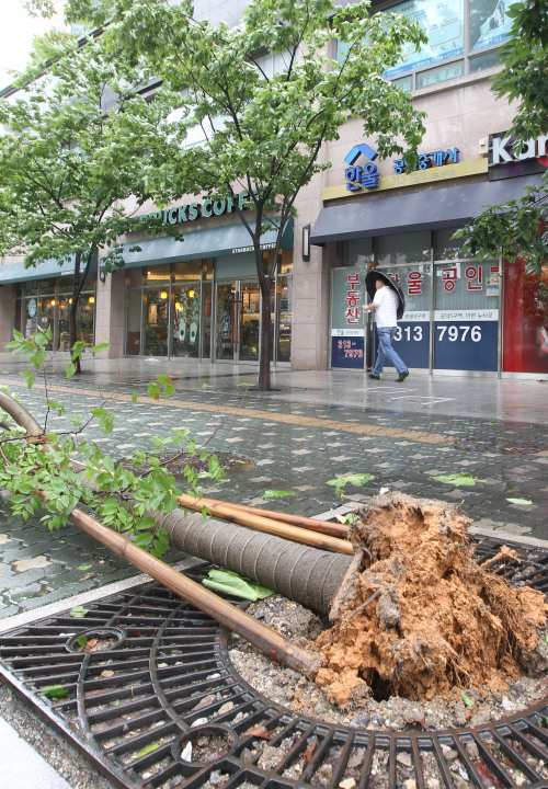
Image: Yonhap News


SEOUL, June 26 (Yonhap) -- Typhoon Meari brought heavy downpours and gusts across South Korea Sunday to kill two people and knock out power and suspend domestic flights.

A rescue official in South Korea's eastern province of Gangwon was killed during a search-and-rescue operation for a missing toddler, the National Emergency Management Agency (NEMA) said.

A student presumed to be 15 years old was found dead after being washed away in rapid torrents in Chungju, 147 kilometers southeast of Seoul, according to the local anti-disaster agency.

The gusts knocked over power lines in the southern resort island of Jeju, leaving hundreds of people without power for up to one hour and forcing several airports on the island and in other provinces to cancel dozens of domestic flights.

Still, no disruptions of international flights were reported at the country's two major airports in Seoul and Incheon, west of Seoul, according to aviation officials.

Meari, the Korean word for "echo," passed through the country's southwest coast early Sunday and was expected to reach North Korean waters later in the day before landing on the northern part of North Korea on Monday morning, the NEMA said on its Web site.

The North issued a typhoon warning and braced for heavy rains and strong winds, the country's state broadcaster said.

North Korea has launched a nationwide campaign to try to prevent damage from heavy rainfall, the country's official Korean Central News Agency (KCNA) reported Saturday.

The Korean Peninsula is expected to be rid of the typhoon by Tuesday morning, the NEMA said.

The downpours also submerged several houses, 581 hectares of farmland and dozens of greenhouses while destroying several streets and a rail bridge in the country's central and southeastern areas.

Meanwhile, the Seoul Metropolitan Government has set up a disaster control center to deal with possible damage to property and other structures from the typhoon.

On the way to the Korean Peninsula, the typhoon pounded several Southeast Asian countries, resulting in 13 deaths in Vietnam and 15 people missing in the Philippines, according to news reports.

Last year, powerful Typhoon Kompasu swept through the country, killing five people and causing some 23.3 billion won (US$19.9 million) worth of property damage.

Typhoon Meari : Moves Up China's East Coast to South Korea

East China coast braces for tropical storm Meari (Xinhua News)
Image: Zinhua News


East China coastal regions are bracing for strong gales and heavy rains as tropical storm Meari moves northward.

The tropical storm will shave off the eastern coasts of Shandong Peninsula or may make a landfall around the region between Sunday afternoon and evening before shifting to head northeastward to the border areas between China and the Democratic People's Republic of Korea, according to the National Meteorological Center (NMC) Sunday morning.

Off the coast of east Shandong Province, the stormy weather sank three ships with 17 people on board. Fifteen people have been rescued while two fishermen were still missing as of midday Sunday, said a spokesman. according to a spokesman with the Shandong Maritime Safety Administration.

Meari, with a wind speed of 90 km per hour near its center, was moving northward at the speed of 40 km per hour Sunday morning, twice as fast as it traveled Saturday afternoon, according to the Shenyang Municipal Meteorological Center.

Gales whipped through the Bohai Strait and over the northern part of the Yellow Sea on Sunday and torrential rains pounded most parts of Liaoning, particularly the cities of Dalian and Dandong, according to the center.

The typhoon alarm for Shanghai has been lifted as Meari's impact on the city was less severe than expected, said the Shanghai Municipal Meteorological Center.

Wednesday, June 22, 2011

Tropical Cyclone "Falcon" [International Name: Meari]

New low pressure area to enter Philippine area of responsibility as tropical cyclone Falcon (Vox Bikol)

Not long after Egay (Haima) made landfall along China's south coast, another ex tropical low formed off the coast of Philippines.

Exit Egay, enter Falcon:
Image courtesy of: Hong Kong Observatory iPhone application

Naga City Philippines (June 21, 2011 7:25 A.M.) - A low pressure area (LPA) South East of the Visayas, although still too far to affect any part of the Philippines, is fast organizing and expected to become Tropical Cyclone 'Falcon' today as it enters the Philippine Area of Responsibility (PAR).

Threatened areas include Eastern Visayas, Bicol Region and the rest of Luzon as the weather disturbance moves Westerly at 13 kilometers per hour in the general direction of Eastern Luzon, packing a center wind of 40 kilometers per hour with gustiness up to 55 kilometers per hour.

As of 6:00 A.M. today, the center of Tropical Disturbance 99W is located 725 kilometers East Southeast of Borongan, Eastern Samar or 1000 kilometers East Southeast of Naga City at coordinates 10.9º North Latitude 132.0º East Longitude.


Tropical Storm Haima (aka Egay) Hits Southern China


Image: [A man cycles on a stone bridge submerged underwater past a boat at the flooded Donghu Lake in Wuhan, Hubei province, June 21, 2011] Courtesy of: Reuters.


Tropical storm "Haima" has brought gusty wind and squally showers to Hong Kong. Other parts of Southern China have suffered from flooding. The Hong Kong ovservatory has hoisted their "signal number three" wind advisory, as a precautionary measure:

Hong Kong Observatory (Precautionary Measures)
Secure all loose objects, particularly those on balconies and rooftops. Flower pots and other objects likely to be blown away should be taken indoors. Secure hoardings, scaffoldings and temporary structures. Drains should be cleared to avoid blockage and overflows. Stay away from the shoreline and not to engage in water sports. Fishing vessels should seek shelter without delay. Listen to radio and TV announcements and browse the Observatory website for further information about the tropical cyclone.

Storm brings worsening weather to Hong Kong (RTHK)

Heavy rain and strong winds are expected to continue to hit Hong Kong overnight, as Tropical Cyclone Haima passes the territory. The strong wind signal number three remains in force.

However, the Observatory says the chances of a higher signal are low. Winds have brought down dozens of trees around the territory. One person has been injured.

Some services have been affected and kindergartens and special schools have been suspended. But there have been no reports of flooding or landslides.


Tropical storm "Haima" to bring heavy rain
(dongguantoday)
Image courtesy of: whatsonsanya
Tropical storm Haima is expected to land between Taishan and Xuwen, west Guangdong tonight, bringing heavy rain to most areas in Guangdong.

The storm was 480 km southeast to Yangjiang at 8 p.m. yesterday and moving northwest. The provincial Emergency Management Office has launched IV emergency reaction plan.

Rainstorms are expected in Zhanjiang, Maoming, Yangjiang, Jiangmen, Zhuhai and Zhongshan, heavy rains are expected in other Pearl River Delta area and east and northwest Guangdong from this afternoon to tomorrow.

Tuesday, June 21, 2011

Cyclone Passes Close to Hong Kong

Strengthening winds - possibly reaching gale force - are expected this evening together with showers as a tropical depression moves closer to Hong Kong. For most parts of the city it's business as usual:

Image by Slipstream (taken earlier today)

Cyclone bears down on Hong Kong (The Standard)

The Standby No 1 Signal was hoisted at 9.35pm last night as the depression moved within 100 kilometers of Dongsha and less than 500km from Hong Kong.

Hong Kong Observatory scientific officer Wong Wing-tak said on its current course it will pass quite close to Hong Kong tomorrow.

"We expect it will get quite close but not a direct hit," Wong said, adding the cyclone is still likely to bring squally showers and gusty winds.

Heavy showers are forecast for tomorrow and Thursday with occasional showers for the rest of the week and thunderstorms on Sunday.

Wong said on average Hong Kong experiences about six tropical cyclones each year though not all hit the territory directly.

While the current cyclone does not appear strong, it may intensify. "This one is now very weak but we expect it to interact with the cloud system nearby and that after the interaction it will become bigger and stronger," Wong said.

The incoming cyclone may also have contributed to the flush of hot weather Hong Kong has experienced over the past few days.

"When there's a tropical cyclone in the area, the air that goes up will have to come down somewhere else," Wong said. "When the air subsides it will heat up the atmosphere."

A hot weather warning has been in effect for several days and the Department of Health is warning residents to take measures to avoid heatstroke and sunburn.

--Snip--

Friday, June 10, 2011

Tropical Storm Sarika

Screenshot: Hong Kong Observatory (iPhone App)

Tropical storm Sarika sprung up during the early hours Friday morning (HKT). Some casualties have been reported.

Six dead as storm exits Philippines

MANILA — Six people were killed and 27 others were missing at sea as Tropical Storm Sarika headed out of Philippine waters Friday with many communities still flooded, rescuers said.

Four people drowned in the major southern island of Mindanao earlier this week while a boy died after falling into a swollen creek in Batangas city near Manila, and a woman drowned on the central island of Tablas, they said.

The National Disaster Risk Reduction and Management Council said 26 Filipino fishermen were missing near the Spratly Islands in the South China Sea.

One crew member of a barge went missing as the vessel, which was carrying agricultural products, was driven by strong winds off the town of Sariaya, south of Manila, it added.

Several hundred people remained at evacuation centres across Luzon early Friday while waiting for floodwaters to recede, the disaster council said in its latest update.

Sarika was heading for southeastern China on Friday with peak winds of 65 kilometres (40 miles) an hour, after brushing the west coast of the main Philippine island of Luzon, the state weather service said.

As Sarika swings past Hong Kong, the T1 signal has been hoisted as a precaution. Sarika is not forecast to strengthen, and is anticipated to mainly bring a fresh breeze, high humidity and squally showers.

Weather: Hong Kong issues alert v.s. 'Sarika

As tropical storm "Dodong" (international name Sarika) left Philippine territory and headed for China before noon Friday, Hong Kong authorities issued a standby signal for the approaching cyclone.

The Hong Kong Observatory issued a "number one standby signal" as "Sarika" neared China, although it said it does not expect to issue a Strong Wind Signal within the day.

"The Standby Signal, No. 1, is in force. This means that a tropical cyclone now (centered) within about 800 (kilometers) of Hong Kong may affect us," it said.

According to the latest forecast track, "Sarika will maintain some distance from Hong Kong today and local winds are not expected to strengthen significantly. The chance of issuing Strong Wind Signal No. 3 today is not high," it added.

Shortly after making landfall on the south coast of china, it's forecast to weaken into an ex tropical low before it eventually dissolves. This is estimated to happen within the next two to three days.

Thursday, June 09, 2011

Adrian becomes 1st East Pac hurricane - grows fast

Graphic courtesy of Weather Underground


The storm that was tropical depression 1E just a day ago has now grown into a major Category 4 hurricane. Hurricane Adrian became a named storm early Wednesday and grew to hurricane strength by the end of the day. Since then the storm has continued to rapidly intensify reaching sustained windspeeds of 140 MPH with gusts of 165 MPH.

Adrian Becomes Category 4 Hurricane(AccuWeather)
Tropical Storm Adrian, the first hurricane of 2011, is now a Category 4 storm in the eastern Pacific.

Adrian was upgraded to a hurricane Wednesday evening and was upgraded to Category 4 status at 4 p.m. PDT on Thursday.

After organizing into the first tropical depression of the 2011 Eastern Pacific Hurricane Season on Tuesday morning, rapid strengthening continued throughout the day. The depression was named Tropical Storm Adrian on Tuesday.

Adrian is forecast to strengthen further before steadily weakening as it enters cooler waters. Adrian's path is to the west northwest essentially parallel to the Mexican coast and is not expected to affect land.

Tuesday, June 07, 2011

Tropical Depression 1E forms in the East Pacific


Tropical depression 1E has formed in the eastern Pacific Ocean off the coast of Mexico. Current computer models indicate that this storm will most likely track in a north-westerly direction parallel to the Mexican coast.

This storm is likely to organize further into a tropical storm within the next 24 hours becoming TS Adrian. The expectation is that the storm will continue to strengthen into a hurricane by the end of the week.

Graphics courtesy of Weather Underground

Thursday, June 02, 2011

Tornado Hits Springfield Massachusetts


Video Courtesy: WGGB (www.wggb.com)

2010 Atlantic Hurricanes (courtesy of Weatherstreet.com)

NOAA Gulf of Mexico Radar (courtesy of Weatherstreet.com)

NOAA West Atlantic & Caribbean Radar (courtesy of Weatherstreet.com)

NOAA East Atlantic Radar (courtesy of Weatherstreet.com)