Gulf Coast Hurricane Tracker

A single source reference on tropical weather predictions. With a traditional focus on the upper Texas and Louisiana Gulf Coast we've maintained links to track all Atlantic Basin, Caribbean and eastern Pacific storm systems. We are now expanding our view to tropical storms throughout the world intending to be a comprehensive global storm tracking resource.

Thursday, June 22, 2006

I'm not sure about Global Warming, but the "HOT AIR" sure is flowing freely

Wednesday morning the northern hemisphere of our fine planet experienced the summer solstice. Guess what - it's hot. Here in Houston we've had 90 degree weather for a couple months now but that is perfectly normal. I noticed that several cities around the country still had highs in the upper 70's earlier this week but I think the highs in those areas are climbing also.

So what does this mean? - it means that the environmental alarmists are panic-ing.

I don't think that there is any surprise in the timing of the release of Al Gore's film "An Inconvenient Truth". If you want to emphasize the imminent danger created by the Earth getting hot you certainly are not going to release it when the weather is cool. I did find it gratifying to find a couple of articles from Canada posted on Drudge Report and Junk Science in which a large number of climate scientists disagree with the basic tenants and conclusions drawn in the movie. As I discussed in a couple of posts earlier, the general consensus was that it was nothing more than science fiction.

Well now the other shoe drops. Yesterday and today several reports have been published once again stating that global warming is real and that it was been caused by humans. I discuss some of these articles below.

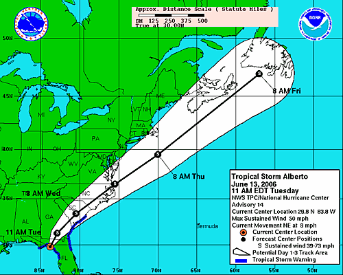
Global warming surpasses natural cycles in fueling 2005 hurricane season (from physorg.com)


"Global warming accounted for around half of the extra hurricane-fueling warmth in the waters of the tropical North Atlantic in 2005, while natural cycles were only a minor factor, according to a new analysis by Kevin Trenberth and Dennis Shea of the National Center for Atmospheric Research (NCAR). The study will appear in the June 27 issue of Geophysical Research Letters, published by the American Geophysical Union."


According to this article, Drs. Trenberth and Shea analyzed sea surface temperatures since the early 20th century. They compared the temperature data in the 1990's to the overall average from 1901 through 1970. This showed that the increase in hurricanes (number and intensity) was caused by warmer water temperatures. The problem is that they could not tell how much of the warming was caused by the AMO (The Atlantic Multidecadal Oscillation) and how much was caused by Global Warming.
"But Trenberth, suspecting that global warming was also playing a role, looked beyond the Atlantic to temperature patterns throughout Earth's tropical and midlatitude waters."

So my understanding of this statement is that when the data doesn't support the predrawn conclusion, expand the data set until it does. When the data from the North Atlantic did not clearly show that global warming was the primary cause, these scientists used data from other areas to create some type of base line. They then subtracted that baseline and said that that was the difference caused by global warming. This is basically the same technique used in economics to remove seasonal affects from product forecasts.

The problem is that the data is not legit. First of all, sea surface water temperature measurements in the first half of the 20th century were taken manually primarily by sticking a thermometer into a bucket of freshly drawn water. There were no controls on location or time stamps. Current temperature measurements are by automated buoys that are stationary and record the temperature at set times each day (typically every 1 minute). So a comparison is dubious at best.

I also question the legitimacy of using data from outside the North Atlantic to draw conclusions about the North Atlantic. Yes global warming should be taking place globally, but the data seems to be centered around North America and Europe, primarily because that is where the most temperature measurement equipment is located. But is there really a measurable effect of global warming in these areas? Anecdotal evidence certainly doesn't support that there is an increase in cyclone formation or intensity in the Pacific for example. Is the use of data from say the Pacific or Indian Ocean relevant for drawing conclusions of the North Atlantic? I have my doubts.

I also find it interesting that the article ends with the standard caveat that this is what we think but just because it doesn't happen doesn't mean we are wrong. Talk about covering both bases.


Earth hottest it's been in 2,000 years (from Breitbart.com)

The Earth is running a slight fever from greenhouse gases, after
enjoying relatively stable temperatures for 2,000 years. The National Academy of
Sciences, after reconstructing global average surface temperatures for the past
two millennia, said Thursday the data are "additional supporting evidence ...
that human activities are responsible for much of the recent warming."

The National Academy of Sciences is basically rehashing the same story that we've been hearing for years: The temperature rise in the 90's is the worst that there has ever been and humans are causing it. They categorically dismiss the medieval warm spell as insignificant. I also find it interesting that while high methane and CO2 levels were determined to exist in those times, they were caused by volcanoes but the higher CO2 that exists today is from cars so somehow it is more dangerous (?).

I find it interesting that the Earth was able to recover then but the underlying assumption is that this time we will hit a tipping point that will take us over the precipice. Unless we plunge into an Ice Age (and isn't that the Earth recovering on its own)

Here is essentially the same article from CNN and Fox News


Science Panel Backs Study on Warming Climate (Huh????) (from New York Times)

This is an interesting headline until you read the article. The panel's comments include:

  • a statistical method used in the 1999 study was not the best
  • some uncertainties in the work "have been underestimated,"
  • it particularly challenged the authors' conclusion that the
    decade of the 1990's was probably the warmest in a millennium
  • The experts said there was no reliable way to make estimates
    for surface-temperature trends in the first millennium A.D
    .

This is support?!?! I'd hate to read what would have been said if the panel rejected the report.

Additionally, "challenges to the 1999 work by Sen. Inhofe (R-OK) and Rep. Barton (R-TX) citing peer reviewed papers challenging the methods [used]".

The main critiques were done by Stephen McIntyre, a statistician and part-time consultant in Toronto to minerals industries, and Ross McKitrick, an economist at the University of Guelph in Ontario.


They contended that Dr. Mann and his colleagues selected particular statistical methods and sets of data, like a record of rings in bristlecone pine trees, that were most apt to produce a picture of unusual recent warming. They also complained that Dr. Mann refused to share his data and techniques. In an interview, Dr. Mann expressed muted satisfaction with the panel's findings. He said it clearly showed that the 1999 analysis has held up over time. But he complained that the committee seemed to forget about the many caveats that were in the original paper. "Even the title of the paper on which all this has been based is as much about the caveats and uncertainties as it is about the findings," he said.

So basically the report was based on a number of possibly unrelated data sets cited a bunch of "caveats". OK...This is legit as long as it is cited and utilized properly, but this report and similar studies are being used to set public policy and create general panic. And that is just plain WRONG!

I guess the NYT just puts the headline they want and hope we don't actually read the article.

Trackback to The Dumb Ox, Woman Honor Thyself, Michelle Malkin


Tuesday, June 20, 2006

Visit "The Dumb Ox"


I just want to take a short break from the weather and climate to request that any readers whom have come here directly either via your favorites or directly please visit "The Dumb Ox" (The title of this post will link directly to the site). I think most of us reading this have come from the D. O. thanks to the Trackbacks.

The Dumb Ox has a full range of everything we all need for a quality life:

Current world events
Spiritual enlightenment
News updates from Reuters (complete with video)
Comics
Games (fun stuff and intellectual challenges)
Links to the scripture readings
Sidebar links from 2 news sites and from Catholic Culture.org

The Dumb Ox is the perfect way to start the day to know what is happening in the world, what is important (not necessarily the same thing) and for an occasional diversion.

So please check out: The Dumb Ox <http://thomistic.blogspot.com/>

Without the help of D. Ox I think this first attempt at a blog would have been as successful as Rat implies here (thanks and apologies to Steve Pastis). Thanks to D. Ox and all of you for coming here to see what I've had to say. It really makes me feel good to receive the kind remarks from y'all.

Monday, June 19, 2006

Heavy flooding in Houston

Below is a compilation of links to some of the reports on the Houston flooding. The storms are affecting southest Texas from west of Houston all the way to Louisiana and parts of Louisiana west of Lake Charles. Governor Perry has called out the National Guard and many people have had to be rescued from their cars.

Check out the Houston Radar link in the sidebar for current storm activity.

Reuters: http://today.reuters.com/news/newsarticle.aspx?type=domesticNews&storyID=2006-06-19T164555Z_01_N19452448_RTRUKOC_0_US-WEATHER-HOUSTON.xml&WTmodLoc=NewsArt-L3-U.S.+NewsNews-2

Houston Chronicle: http://chron.com/disp/story.mpl/metropolitan/3982027.html

Breitbart.com News: http://www.breitbart.com/news/2006/06/19/D8IBD75G0.html

Fox News: http://www.foxnews.com/story/0,2933,200078,00.html

CNN: http://www.cnn.com/2006/WEATHER/06/19/texas.rain.ap/index.html

The heavy rain is not over in Houston

The rain has settled some in the Houston Metroplex with the heaviest rain along the Brazoria county coastline. The link is to Davis Paul's forecast from KHOU. He is expecting more heavy rain late this afternoon or overnight as the storm circulates around the low pressure system. Up to 11 inches of rain has fallen in the area between Pasadena and Hobby Airport. Most of this rain haas fallen over just 2 hours. The drainage systems are not designed for this much rainfall in such a short period of time.

The storm appears to be circultaing around the Low pressure which is currently to the east of Houston. David Paul forecast at 9:57 see link here

http://www.khou.com/sharedcontent/VideoPlayer/makeASX.php?title=www.khou.com/david9a_060619.wmv&adurl=&adclickthru=&adgraphic=

discusses how he expects the center of the low pressure to track either to the southwest or to the west. The heaviest rain will follow the track of the low and flooding is likely along this track. It will only take 5 inches or so to add to the flooding as the bayous and streams are already above their banks.

Wednesday, June 14, 2006

Friends Of Science Critiques The Evidence For Man-Made Climate Change

By way of Junk Science.com www.junkscience.com

More scientists are publicly questioning the certainty of the data surrounding climate change. The fact is that there is much uncertainty in the data and to make claims that catostrophic change is imminent is just plain wrong.

Once when I was discussing Global Warming with a colleague (an educated engineer) I repeatedly hit upon the data questioning the so-called accepted conclusions. His comment, which quickly stifled the conversation, was that there were a whole lot of smart people who "ought to know" these things that said that global warming was happening and that was good enough for him. At that point I excused myself and drifted away.

The point is... Many of the most vocal proponents of Global Warming have a clear agenda. A bunch of people accept their word because of who they are - actors, politicians who are for the people, etc. but they don't look to the data and evidence except as it supports their side. People are trying to draw long term planet wide conclusions on the basis of the fact that it was hot last summer.

The current satellite data even supports the concept that the warming trend ended in 1998 and we have generally been in a slight cooling mode ever since - let's see after a decade worth of data collection if that is true. You cannot discern a trend with only a few data points.

Tuesday, June 13, 2006

Possible concensus on Al Gore's "An Inconvenient Truth"?

This article from the National Post on www.canada.com discusses the comments by scientists working in the field studying global warming and climate change. The repeated apparent concensus is that the film "amounts to little more than science fiction" and real climate scientists are afraid that the public will not realize it.

The article is two and a half pages long with a page and a half of comments from scientists pointing out the falicies that Gore claims as fact in the film. This clearly illustrates how the former VP has turned a scientific issue into a political one by "Playing on our fears!"

Alberto is on Land now


The eye of the storm has come ashore this morning. Fortunately winds never did reach hurricane strength. The storm track posted here shows a long stretch over land before the eye passes back over water around the VA/NC border.

The issue now is primarily rainfall and I'm sure flooding is a concern. The tropical update a few posts down explains the official concerns much better than I can. It is interesting to me that the strength of Alberto is being predicted to hold at a Tropical Storm level across the land. Earlier the prediction was for it to drop back to a depression and then reform once it got out in to the Atlantic. I wonder if there is much of a risk along the coast or into Canada. We will keep a watch on this storm until the advisories are cancelled.

Monday, June 12, 2006

Well, There they go again

Bill Clinton and Al Gore are linking the Bush administration policies to increased hurricanes. "See we were right about global warming". It is interesting that the liberals will claim that the republicans ignore science yet they ignore recognized hurricane experts like Dr. Max Mayfield of the Hurricane Center and Dr. Bill Gray of the University of Colorodo when they state that the current increase in hurricanes are all part of the natural decadal cycle.

Tropical Storm Alberto gains strength. May become the first hurricane of 2006

The first tropical storm of the year suddenly gained strength today and may increase to hurricane force before landfall. Storm surge as high as 10 feet has been predicted in some areas. Florida was looking forward to the increase in rain but the added wind makes this dangerous even at a Cat 1.

Check the Tampa radar and the tropical updates below for current progress of this storm.

Update: 10:48 pm

Earlier today the storm looked like it was going to grow to hurricane strength. The winds picked up from 45 MPH to 70 MPH. Fortunately the winds have stayed at 70 MPH but even so, Hurricane warnings have been issued for the Florida gulf coast at approximately 22,000 people have been ordered or suggested to evalcuated. According to The Weatehr Channel and CNN reports, the only mandatory evalcuations were the very low lying areas on the coast.

The link below is for the MSNBC report on the storm.

http://www.msnbc.msn.com/id/13272123/

The eye of the storm is expected to come ashore at around 7 am Tuesday and will likely remain disorganized.

Sunday, June 11, 2006

Tampa Radar

This link will take you to the Tampa radar as Tropical Storm Alberto approaches.

Saturday, June 10, 2006

Tropical Storm Alberto Advisory (Updated)

This Link remains live for Tropical Storm Alberto.

First Tropical Depression of 2006 forms

The National Hurricane Center has issued its 2nd advisory on TD #1. Tropical storm warnings are recommended for the Cuban provinces of Pinar del Rio and the Isle of Youth.

The track from Weather Underground and computer models from Skeetobiteweather.com are posted here by way of the Drudge Report.


As of 10:00 CDT the poorly defined center of Tropical Depression 1 was estimated near latitude 21.5 N ... longitude 85.6 W ...Aprroximately 45 miles WSW of Cabo San Antonio on the western tip of Cuba. The depression is moving NNW new 12 MPH and this motion should continue for the next 24 hours.

Max Winds are 35 MPH with gusts up to 45
Min pressure is 1003 mbar (29.62 inches Hg)

Tropical Weather Outlook 05:30 Update

The short of it is that nothing has changed overnight but the conditions are still favorable for development. This time of year, storm formation is primarily in the Gulf or western Caribbean.

Friday, June 09, 2006

National Hurricane Center Tropical Weather Outlook

From the National Hurricane Center in Miami, Fl. This could be the start.

------------------------------------------

10:30 EDT Friday Jun 9, 2006

For the North Atlantic... Caribbean Sea and the Gulf of Mexico

A broad area of low pressure centered between Honduras and western Cuba has changed little in organization during the past few hours. However, ... conditions appear to be favorable for this system to become a tropical depression or a tropical storm during the next 12 to 24 hours. This system is expected to move northward across extream western Cuba and the Yucatan Channel bringing squalls and additional rains to the Cayman Islands and portions of Cuba. An Air Force reconaissance aircraft is scheduled to investigate this system tomorrow afternoon ... if necessary.

All interests in the northwestern Caribbean Seaand the southeastern Gulf of Mexico should closely monitor the progress of this system. Because development could occur near Cuba at any time on Saturday ... A tropical storm watch or warning may be required for portions of western Cuba.

Elsewhere ... tropical storm formation is not expected through Sunday.

Forecaster Avila

2006 Hurricane Names

Alberto Beryl Chris Debby Ernesto Florence Gordon Helene Isaac

Joyce Kirk Leslie Michael Nadine Oscar Patty Rafael Sandy Tony

Valerie William

NOAA's 2006 Atlantic hurricane season outlook


NOAA’s 2006 Atlantic hurricane season outlook indicates an
80% chance of an above-normal hurricane season,
a 15% chance of a near-normal season,
and only a 5% chance of a below-normal season
.

This outlook is produced by scientists at the National Oceanic and Atmospheric Administration's (NOAA) Climate Prediction Center (CPC), National Hurricane Center (NHC), and Hurricane Research Division (HRD). See NOAA’s definitions of above-, near-, and below-normal seasons.

The outlook calls for a very active 2006 season, with 13-16 named storms, 8-10 hurricanes, and 4-6 major hurricanes.

The likely range of the ACE index is 135%-205% of the median. This prediction indicates a continuation of above-normal activity that began in 1995. However, we do not currently expect a repeat of last year’s record season.

The predicted 2006 activity strongly reflects an expected continuation of conditions associated with the multi-decadal signal,which has favored above-normal Atlantic hurricane seasons since 1995. These conditions include considerably warmer than normal sea surface temperatures (SSTs), lower wind shear, reduced sea level pressure, and a more conducive structure of the African easterly jet.

An updated Atlantic hurricane outlook will be issued in early August, which begins the peak months (August-October) of the hurricane season.

The full NOAA prediction report can be read by clicking the title of this post.

Houston/Galveston Radar

This is a live link to the National Weather Service radar for the Houston-Galveston, TX area

2006 Hurricane Season Forecast - AccuWeather

IBISeye - Hurricane Tracking Service

This link is to a hurricane tracker that has been launched by the Sarasota, Florida Herald-Tribune. It utilizes Google Maps, census data and more.

My First Post - Updated 16:12

Welcome to the newly created Gulf Coast Hurricane tracker. I will try to develop this site so that it serves as a single tool to help us during this 2006 hurricane season which started last week. There is already a disturbance just south of the Mexican peninsula that is expected to head north or northeast over the weekend. Expectations are that it will end up in the Bay of Campeche or on the ende of the Yucatan by the beginning of next week. If it exds up in the Bay then conditions may be right for some strengthening.

Stay Tuned.

2010 Atlantic Hurricanes (courtesy of Weatherstreet.com)

NOAA Gulf of Mexico Radar (courtesy of Weatherstreet.com)

NOAA West Atlantic & Caribbean Radar (courtesy of Weatherstreet.com)

NOAA East Atlantic Radar (courtesy of Weatherstreet.com)