Gulf Coast Hurricane Tracker

A single source reference on tropical weather predictions. With a traditional focus on the upper Texas and Louisiana Gulf Coast we've maintained links to track all Atlantic Basin, Caribbean and eastern Pacific storm systems. We are now expanding our view to tropical storms throughout the world intending to be a comprehensive global storm tracking resource.

Tuesday, May 31, 2011

Atlantic Hurricane Season Begins Wednesday

The 2011 Atlantic Hurricane Season begins tomorrow (Wednesday June 1) and it promises to be another busy one. Last year was a real doozy with the very unusual aspect of there being no US landfall events throughout the entire year. For such a busy season this was very strange indeed. It is unlikely that we will be spared this year.

Forecasters: 2011 Tropical Storm Season Busy, But Slower Than 2010 (Property Casualty 360)
Another weather forecasting team is predicting an active hurricane season for 2011, calling for an above-average number of storms to form in the Atlantic Hurricane Basin.

Earth Networks’ WeatherBug meteorology team foresees a lower number of expected hurricanes in comparison to 2010, but its numbers are still trending above what is considered to be a normal tropical storm season.

Specifically, Earth Networks expects a total of 13-14 named storms to form, with 7-8 becoming hurricanes. Of those, it expects four will become strong enough to be classified at “intense” storms—Category 3 or higher on the Saffir-Simpson scale.

An average tropical storm season is 10 named storms, six hurricanes, and 3 intense hurricanes.
The key factor in why 2010 was so active of a year was La Nina. La Nina conditions typically favor the development of tropical activity in part by lowering the pressure in the Atlantic Basin and also by promoting warmer water in the Atlantic, Caribbean and Gulf of Mexico. This year La Nina is expected to weaken. Also the sea surface temperatures are not as high as they were this time last year.

The combination of a weakening La Nina plus slightly lower sea surface temperatures is expected to lessen the tropical activity this year, however it is still expected to be an above average year.

NOAA Hurricane Outlook Indicates an Above-Normal Atlantic Season (AccuWeather)
Climate factors considered for this outlook are:

* The continuing high activity era. Since 1995, the tropical multi-decadal signal has brought ocean and atmospheric conditions conducive for development in sync, leading to more active Atlantic hurricane seasons.

* Warm Atlantic Ocean water. Sea surface temperatures where storms often develop and move across the Atlantic are up to two degrees Fahrenheit warmer-than-average.

* La Niña, which continues to weaken in the equatorial Pacific Ocean, is expected to dissipate later this month or in June, but its impacts, such as reduced wind shear, are expected to continue into the hurricane season.

"In addition to multiple climate factors, seasonal climate models also indicate an above-normal season is likely, and even suggest we could see activity comparable to some of the active seasons since 1995," said Gerry Bell, Ph.D., lead seasonal hurricane forecaster at NOAA's Climate Prediction Center.

NOAA's seasonal hurricane outlook does not predict where and when any of these storms may hit. Landfall is dictated by weather patterns in place at the time the storm approaches. For each storm, NOAA's National Hurricane Center forecasts how these weather patterns affect the storm track, intensity and landfall potential.

"The tornadoes that devastated the South and the large amount of flooding we've seen this spring should serve as a reminder that disasters can happen anytime and anywhere. As we move into this hurricane season it's important to remember that FEMA is just part of an emergency management team that includes the entire federal family, state, local and tribal governments, the private sector and most importantly the public," said FEMA Administrator Craig Fugate.

"Now is the time, if you haven't already, to get your plan together for what you and your family would do if disaster strikes. Visit ready.gov to learn more. And if you're a small business owner, visit www.ready.gov/business to ensure that your business is prepared for a disaster," added Fugate.

Friday, May 27, 2011

Tropical Moisture Along the Equator Feels Songda's Pull

Songda ramps up to super typhoon strength (www.thehindubusinessline.com)

The pull exerted by Songda on tropical moisture along the equator saw further convergence of monsoon clouds over the south Arabian Sea and adjoining equatorial Indian Ocean past Maldives and even approaching Sri Lanka.

Meanwhile, global models continued to maintain a watch for the formation of a weather system in the southeast Arabian Sea close to the Kerala coast during the first 10 days of June.

Some of these models also hinted the possibility of concurrent activity near the Oman coast during this period but without significant collateral damage to the monsoonal system.

In fact, the Climate Prediction Centre (CPC) of the US National Weather Services in its latest outlook valid for May 25 to 31 pointed to a band of enhanced convection and rainfall extending from south Arabian Sea towards equatorial Indian Ocean and Sri Lanka.

This is likely the handiwork of a Madden-Julian Oscillation (MJO) wave, a periodical upper air low-pressure wave, with direct impact on ground level weather and mostly associated with monsoon onsets.

The eastward propagating wave is seen as crossing into the Bay of Bengal during June 1 to 7 and entering South China Sea and the Maritime Continent (Indonesia, Malaysia etc), which is just as it should.

Global Forecasting System model of the CPC has hinted about the possibility of convective activity peaking to a high in south and southeast Arabian Sea during June 2 to 8.

Meanwhile, India Meteorological Department (IMD) has reduced the countdown for onset of southwest monsoon over South Andaman Sea to two days.

Satellite pictures on Thursday afternoon showed convective (rain-bearing) clouds rising over parts of Jammu and Kashmir, Haryana, northeast Rajasthan, Bihar, Jharkhand, Gangetic West Bengal, Orissa, Madhya Maharashtra, south peninsular India, east and south Bay of Bengal, Andaman Sea and south Arabian Sea.

Super Typhoon Loses Strength as it Approaches Japan

Super typhoon churns through Pacific, threatens Okinawa (www.cnn.com)

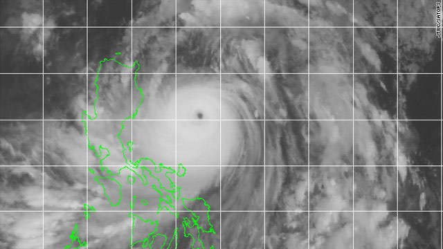
Image courtesy of CNN

Super Typhoon Songda ripped across the western Pacific on Thursday, dropping heavy rain on the Philippines and threatening Okinawa and the Japanese main islands with rain and damaging winds into the weekend.

Songda was a Category 5 storm late Thursday, with maximum sustained winds of 161 mph and gusts of 195 mph, according to the Joint Typhoon Warning Center in Pearl Harbor, Hawaii. The storm was producing wave heights of 38 feet in the Pacific, forecasters said.

The forecast track for Songda put it over Okinawa on Saturday night as a Category 2 storm, with maximum sustained winds of 109 mph and gusts up 132 mph.

Okinawa is home to several U.S. military installations, including Kadena Air Base, home to nearly 18,000 Americans, and Camp Courtney, home of the III Marine Expeditionary Force and its 16,000 Marines, according to U.S. Forces Japan.

The Japan Meteorological Agency said Songda would lose strength but still be a strong storm as it approaches the country's main islands Sunday.

A dip in the jet stream was forecast to weaken Songda and push it toward the northeast and away from Taiwan and China, CNN meteorologist Brandon Miller said.


Meanwhile, residents of Okinawa are gearing up for the approaching typhoon.

Japans Nansei may shut refinery due to typhoon

Japanese refiner Nansei Sekiyu KK, wholly owned by Brazil's state-run Petrobras , said it would decide on Saturday whether to shut its 100,000 barrels per day Nishihara refinery in Okinawa, southwestern Japan, due to a typhoon.

Typhoon Songda is headed directly to Okinawa with strong winds, a Nansei Sekiyu spokesman said.

Japanese maritime authorities have instructed Nansei to suspend berthing operations from 9 a.m. (0000 GMT) on Saturday, the spokesman added. (Reporting by Osamu Tsukimori; Editing by

As typhoon approaches Okinawa, military readies alcohol ban

CAMP FOSTER, Okinawa — Airmen and Marines on Okinawa are banned from drinking alcohol this weekend if and when incoming Super Typhoon Songda nears the island, according to both services.

The ban goes into effect when the storm is within 12 hours of making landfall and the military announces a Tropical Cyclone Condition of Readiness 1 warning level, which was expected to occur sometime Saturday afternoon.

--Snip--

In a prepared statement Thursday, the 18th Wing commander, Brig. Gen. Ken Wilsbach, said typhoons “can pose a significant challenge to military operations on Okinawa — a challenge that requires complete readiness of personnel to prepare for a storm’s arrival and to resume full operations after a storm passes.”

All active-duty servicemembers are covered by the alcohol ban, including those people on leave and those on TDY who are awaiting transportation.

Civilians are not covered but are “encouraged to refrain from alcohol consumption” during the storm.

The alcohol ban will remain in effect until Songda passes and the military declares the situation all clear, according to Wilsbach’s announcement.

Wednesday, May 25, 2011

Taiwan - Possible Sea Alert, Typhoon Unlikely to Hit Land

Weather bureau may issue sea alert for Songda (www.taipeitimes.com)

The Central Weather Bureau (CWB) said yesterday it might issue a sea alert for Typhoon Songda today, adding that the chance of the typhoon’s radius covering the nation remains low.

--Snip--

The bureau may issue a sea alert either this evening or early tomorrow morning if the radius of the storm enters the nation’s sea alert zone, she said.

Lin said the projected path of Songda showed the typhoon continuing along the edge of the Pacific high-pressure system, adding a land alert was unlikely because the storm’s radius has a very low chance of covering land.

Nonetheless, the bureau said the typhoon’s circumference would still bring showers to the northern and eastern parts of the nation, which are the windward side.

Both central and southern Taiwan, which are on the leeward, are expected to have relatively stable weather, the bureau said

Downpours Caused by Songda Flood Parts of Philippines

Thousands evacuated after typhoon flooding (www.gulfnews.com)

Image Credit: AFP

Manila: Thousands of families are being evacuated and hundreds are stranded in southern Luzon while streets in Metro Manila are flooded as Typhoon Songda (known as Chedeng) brought heavy rains last night, officials said.

"We are evacuating 49,893 families from coastal areas for two days," Governor Jose Salceda of Albay, in southern Luzon's Bicol, said in a radio interview."


Volcanic debris

Families living at the foot of the Mayon Volcano in Albay will also be evacuated, said Salceda, adding that thousands could lose their homes when heavy rain sends volcanic debris down the slopes of the active volcano.

NASA sees Tropical Storm Songda singing of rain and gusty winds for the Philippines (www.escience news.com)

Warm sea surface temp and low wind shear enable Songda to strengthen as it curves North


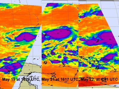
"The series of three infra red images shows the strengthening of Tropical Storm Songda over the period may 19-22, 2011. Notice that the area with the strongest convection (purple) has expanded over that time. That area has the coldest, highest thunderstorm cloud tops neat -63F/-52C, and heaviest rainfall. Over those four days Songda took on a more rounded shape."

Image (above/below) Courtesy of: NASA/JPL, Ed Olsen


--Snip--


"Typhoon Songda was east of the Philippines when the Tropical Rainfall Measuring Mission (TRMM) satellite had an early evening view on May 25, 2011 at 0903 UTC (05:03 EDT) and saw good organization within the storm and heavy rainfall.

Both TRMM's Microwave Imager (TMI) and Precipitation Radar (PR) instruments were used to provide the rainfall analysis. TRMM's TMI had the best coverage of rainfall with Songda and showed well organized bands of moderate to heavy rainfall converging into the typhoon. TRMM is managed by both NASA and the Japanese Space Agency, JAXA.
"


Infrared imagery from the Atmospheric Infrared Sounder (AIRS) instrument on NASA's Aqua satellite showed an eye about 12 nautical miles wide and strong convection surrounding the eye on all sides. Songda intensified over the over the last 12 hours because of very warm sea surface temperatures between 30 and 31 Celsius, and low wind shear.
Cat 4 Typhoon Chedeng Moves Away from Bikol (www.voxbikol.com)


"Naga City (May 26, 2011 5:00 A.M.) - Typhoon Chedeng might have just spared the country from its wrath as it now moves almost directly northward away from the Bikol region, even as it has been upgraded to a Category 4 typhoon with average center wind of 215 kph and gustiness up to 260 kph.

Chedeng's generally northward direction suggests that it may remain at sea until it exits the Philippine Area of Responsibility (PAR) on Saturday evening."

Image Courtesy of: typhoon2000.com

Monday, May 23, 2011

Songda's Silver Lining

Central Weather Bureau Keeps Eye on Tropical Storm (The China Post)

While Philippines gears up for the possible onslaught caused by tropical storm Songda (Chedeng)
, some 2,000km away in Taiwan, there is both caution and hope that it could bring much needed rain to drought affected areas.


Image courtesy of www.philstar.com


Songda, meaning “red tributary” in Vietnamese, was preceded earlier this month by Tropical Storm Aere, which brought rain to the nation’s east coast and Hengchun Peninsula.

--Snip--

Bureau forecaster Lin Ding-yi (林定宜) said that while the storm was still very far from Taiwan, people should not underestimate its force.

“It [the storm] formed at sea,” he said. “The water vapor and heat it absorbs at sea will cause it to become stronger. The crucial time of observation would be on Wednesday or Thursday, when we can better determine if it will affect Taiwan.”


Nonetheless, Lin said that chances of rain were high nationwide tomorrow and Wednesday as another frontal system is forecast to arrive today.


'Severe' storm nears Philippine coastlines (www.philstar.com)

In an advisory issued this morning, the Philippine Atmospheric Geophysical and Atmospheric Services Administration (PAGASA) disclosed that typhoon Chedeng has entered Philippine seawaters past 2:00 a.m. today.

As of 4:00 a.m., “Chedeng” (international codename: Songda) was traced at 880 kilometers east of Guiuan town in Eastern Samar, packing up a maximum sustained winds of 95 kilometers per hour near the center.

PAGASA said the storm’s gustiness could reach as high as 120 kph while moving west-northwest at 13 kph, and is expected to make landfall between Tuesday or Wednesday.

Early today, the National Disaster Risk Reduction Management Council (NDRRMC) has advised residents in the country’s eastern seaboard to brace for the coming storm.

In a television interview, NDRRMC executive director Benito Ramos said residents in low-lying areas must need to evacuate and find shelter in safer grounds.

--Snip--

He also called on the concerned local government units to carry out preemptive evacuation measures to avoid any casualty from the brewing storm.

Sunday, May 22, 2011

Tropical storm upgraded; strikes Yap

Graphic courtesy of Weather Underground

Tropical Storm 04W has been upgraded and named to Tropical Storm Songda. Songda currently has sustained winds in excess of 50 MPH (80 km/hr) and brought strong gusts to the island of Yap in Micronesia. The strength of Songda continues to increase.

Storm ‘Songda’ intensifies further, closes in on PHL(GMA News)
The tropical storm threatening the Philippines intensified further as it continued to move toward Philippine territory Sunday afternoon.

As of 4 p.m., the Philippine Atmospheric Geophysical and Astronomical Services Administration said the storm was some 1,050 km east of northern Mindanao.

Six hours earlier, PAGASA said storm (international name: Songda) was 1,070 km east of northern Mindanao, with maximum sustained winds of 75 kph and gustiness of up to 90 kph

In its 5 p.m. bulletin, PAGASA said the storm now packs maximum sustained winds of 85 kph near the center and gustiness of up to 100 kph.

PAGASA added "Songda" is forecast to move west-northwest at 11 kph. It will be called "Chedeng" when it enters Philippine territory.
At this time, the path of Songda is questionable. Earlier reports indicated that Songda would curve north, miss the Philippines and head towards Japan. That may still be the path this storm takes, however, the slow forward speed has meteorologists at PAGASA concerned. This storm is behaving similar to Philippine storm Bebeng which was a slow lumbering storm which had plenty of time to gain strength and become destructive.

As the Weather Underground graphic above slows, Songda will continue to intensify as it approaches northern Philippines. Forward speed is currently less than 10 km/hr allowing the storm time to gain strength potentially becoming an intense typhoon.

04W Becomes a Tropical Storm, Hits Yap(AccuWeather)
Graphic courtesy of AccuWeather

Tropical Storm 04W is still on track to pose a threat anywhere from the Philippines to Japan. Tropical Storm 04W is expected to reach typhoon strength by early next week.

It gained strength on Saturday as it passed near the Island of Yap in Micronesia. 04W brought wind gusts to tropical storm-force and heavy rain to the island.

The tropical storm will spin into the open waters of the Philippine Sea Sunday, posing little threat to land through most of next week. However, it will steadily strengthen.

Steering currents should take 04W in the direction of the northern Philippines mid to late next week. The big question regarding the track is if 04W will turn north toward Japan, or continue westerly toward the Philippines, Taiwan and eventually China.


Another storm coming to PH area by Sunday, may become typhoon—Pagasa (Philippine Daily Inquirer)
A tropical storm called Songda, which formed near Guam last week, continued its approach toward the eastern seaboard on Sunday, the Philippine Atmospheric, Geophysical, and Astronomical Services Administration (Pagasa) said.

The storm, according to Pagasa’s advisory, has been forecast to enter the country’s boundaries on Sunday night and would be locally code-named Chedeng. It would be the third tropical cyclone of the year and the second this month after tropical storm Bebeng.

As of Sunday morning, Songda was seen 1,070 kilometers east of Mindanao. The agency said the tropical storm was carrying 85 kilometer winds that were gusting at 100 kph. It was traveling west northwest at 11 kph.

Pagasa noted that it has been closely monitoring the cyclone as it has been growing stronger and could be destructive.

Thursday, May 19, 2011

Typhoon Warnings via Facebook and Twitter

U.S. military on Okinawa turns to social media as typhoon season nears (www.stripes.com)


CAMP FOSTER, Okinawa — As the tropical storm season descends on Okinawa, U.S. military officials are telling base residents to keep an eye on Facebook and Twitter for the most up-to-date information.

Social networking proved to be an important tool two months ago in the wake of the earthquake and tsunami in northeast Japan, and again this week when Tropical Storm Aere passed by the island, according to Kadena Air Base spokesman Ed Gulick.

“Facebook has become very important for us,” Gulick said, explaining that posted messages are instant, as opposed to the time it takes to update conventional communication channels. Everything from Kadena’s official website to commander’s TV access channels to the roadside marquees takes time. “And you have to be on base” to see the latter two, he said.

The Facebook pages of Kadena, AFN Okinawa and Marine Corps Bases Japan boast more than 14,000 followers combined.

--snip--

One bit of good news is there is little danger of a Katrina-style fishbowl on Okinawa, which is “built to withstand typhoons and built to shed water, not hold it,” Paslay said. He cited Typhoon Chaba last fall, which dumped 12 inches of rain on Okinawa “and it wasn’t an issue.”

Okinawa remains in seasonal TCCOR-4 from June 1 to November 30, since storms can form even right over the island without warning, officials said. Guam remains in TCCOR-4 year-round.

Tropical cyclones tend to lose most of their strength as they move north toward Japan and Korea, but can still pack a powerful punch and shouldn’t be taken lightly, officials said."


*More information about TCCOR (Tropical Cyclone Conditions of Readiness) and what they mean to U.S. military bases and personnel can be found here: LINK

Wednesday, May 18, 2011

Central Pacific activity expected to be light

NOAA released its projection today that the Central Pacific basin will have a lighter tropical season than normal this year. The tropical season in the Central Pacific begins on June 1 and is expected to have only 2 - 4 tropical cyclones this year.

NOAA expects below normal central Pacific hurricane season (Hawaii News Now)


HONOLULU (HawaiiNewsNow) - NOAA's Central Pacific Hurricane Center said Wednesday that projected climate conditions point to a below normal hurricane season in the Central Pacific Basin this year.

NOAA continues to urge Hawaii residents to be fully prepared for the onset of the hurricane season, which begins on June 1.

"Now is the time to prepare for the hurricane season in the central Pacific," said Ray Tanabe, director of the Central Pacific Hurricane Center, part of NOAA's National Weather Service. "Last year we had a quiet season. It is definitely not the time to let our guard down."

--snip--

For 2011, the outlook calls for a 70% chance of a below normal season, a 25% chance of a near normal season, and a 5% chance of an above normal season.

NOAA expects 2-4 tropical cyclones to affect the central Pacific this season. An average season has 4-5 tropical cyclones, which include tropical depressions, tropical storms, and hurricanes.

This outlook is a general guide to the overall seasonal hurricane activity and does not predict whether, where, when, or how many of these systems will affect Hawaii. Once a tropical cyclone forms in or migrates into the central Pacific or moves into the area, the Central Pacific Hurricane Center swings into action.

Even though the level of activity is expected to be below normal this year, preparation is still important. Hawaiian residents still should be aware of conditions and take the appropriate actions for approaching storms.

The year that Hurricane Andrew raked a path across southern Florida , there had only been two or three storms all year. Andrew was the first and never formed until late September that year. Likewise an active year does not guarantee landfall as was seen during last year's Atlantic Hurricane season.

Only one storm can have a major impact. The key is to prepare for the worst and hope for the best. Once you have the preparations taken care of then you can enjoy the tropical breezes and hot sunny days.

Introducing: Slipstream


Born and raised in Hong Kong, I spent some time in Southern California before returning back to my birthplace to live and work.

When I was a kid growing up in the 80's and 90's, typhoons meant nothing more than time off school and sleepless nights. Memories include listening to the wind howl, soaking up window leaks with towels and buckets, and watching ceiling lights swing as I sat in an apartment 20 floors up.

Having taken up sailing and along with it a greater interest in meteorology, I was happy to get the opportunity to contribute to Gulf Coast Hurricane tracker. As such, I'll do my best to report events as they unfold in and around South East Asia.

Any comments or suggestions appreciated
.

Thanks.

Monday, May 16, 2011

Hurricane season began Sunday in the East Pacific

Hurricane season in the eastern Pacific began on May 15th. This year is projected to be much more active than last year with as many as 15 named storms. Fifteen storms would equal the average for this region of the Pacific basin and would be double the number from last year.

Hurricane Season Starts Today in Eastern Pacific (AccuWeather)
Today (Sunday) marks the official start of the 2011 hurricane season in the Eastern Pacific, a season which is expected to exceed the amount of named tropical systems from last year by twofold.

AccuWeather.com meteorologists are predicting an average number of tropical systems to develop in the Eastern Pacific this year.

The basin averages 15 tropical storms each season. Out of those, nine become hurricanes, with four reaching major hurricane status.

Fifteen named storms would more than double the total from last year. Only seven named storms formed in the Eastern Pacific in 2010, with three reaching hurricane status.
AccuWeather meteorologist explain that last year's low number of hurricanes in the Eastern Pacific was due primarily to the strengthening La Nina cnditions. This year we have a weakening La Nina which will bring lower prossures and warmer sea surface temperatures - conditions conducive for tropical storm formation.

Eastern Pacific Eyes Hurricane Season (Epoch Times)

2011 Eastern Pacific Names
Adrian
Beatriz
Calvin
Dora
Eugene
Fernanda
Greg
Hilary
Irwin
Jova
Kenneth
Lidia
Max
Norma
Otis
Pilar
Ramon
Selma
Todd
Veronica
Wiley
Xina
York
Zelda

Wednesday, May 11, 2011

Tropical Storm Aere: May 6-11, 2011

New Post by Slipstream on location in Hong Kong:


Tropical storm Aere (or Bebeng as it is referred to in the Philippines), left nine people dead as it pounded eastern provinces of the Philippines and brought flooding to the capital [Manila], leaving thousands stranded in ports”. Bloomberg (SOURCE)

Three of the dead were a result of landslides, and much of the flooding was attributed to blocked drains, caused by improperly disposed garbage and poor drain maintenance.


A passenger bus navigates a flooded highway in suburban Makati city, east of Manila, in the Philippines on Sunday, May 8, 2011. (AP Photo/Bullit Marquez)

2010 Atlantic Hurricanes (courtesy of Weatherstreet.com)

NOAA Gulf of Mexico Radar (courtesy of Weatherstreet.com)

NOAA West Atlantic & Caribbean Radar (courtesy of Weatherstreet.com)

NOAA East Atlantic Radar (courtesy of Weatherstreet.com)