Gulf Coast Hurricane Tracker

A single source reference on tropical weather predictions. With a traditional focus on the upper Texas and Louisiana Gulf Coast we've maintained links to track all Atlantic Basin, Caribbean and eastern Pacific storm systems. We are now expanding our view to tropical storms throughout the world intending to be a comprehensive global storm tracking resource.

Monday, October 23, 2006

South Texas deluge Round 2

UPDATE: Color enhanced sattellite image shows moisture from now Tropical Storm Paul streaming into west Texas. I still expect that as the front moves across the area the moisture will be pulled south and east into our direction. It also looks like the storm is slowing down which will provide more time for moisture to be pumped into the area.


South Texas needs to prepare for another deluge like we had last week. Hurricane Paul is slowly heading towards the Mexican coast at approximately six miles per hour. At this slow speed, rainfall amounts over any given area can be expected to be rather significant.

Paul was a strong Cat 2 storm this morning but is already a Cat 1 with winds at 90 MPH. Once the storm hits land the winds will die off but the rain will continue.

Extrapolating the path of the storm indicates, in my opinion, a strong potential for heavy rain in south to central Texas. With a high pressure system located over northern Louisiana and another near the four corners region the storm will likely be channeled right into the Lone Star State. A front will be passing through here sometime on Thursday so it could pull the storm towards the Gulf. My untrained opinion is that we will see the remnants of Paul settle in across the central Texas Hill Country and into the Houston area.

The short of it is that I expect we will get very wet this weekend or early next week.


Trackbacked to Dumb Ox News

Monday, October 16, 2006

Tropical Storm Norman


UPDATE (10/16/06):

Click on the title link for a report from KHOU-TV Channel 11 in Houston. Includes weather forecasts for the area, storm warnings and reports on the flooding and other damage. As of 5 pm there have been 4 deaths from this storm.

Severe Weather slide show part 1, KHOU-TV
Severe Weather slide show part 2 KHOU-TV

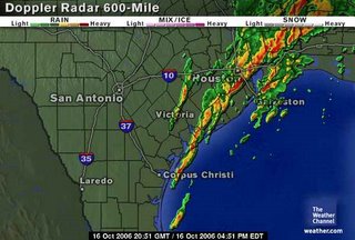
These storms are all th result of moisture that was Tropical Storm Norman that is crossing Mexico and inundating southeast Texas and southwest Louisiana with heavy rain. A front is located near the northeren part of the state and is helping to push the storms south and east through Houston and Beaumont, TX and Lake Charles, La.

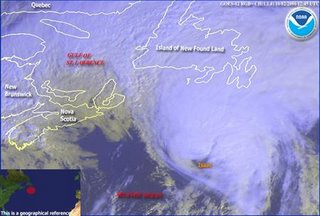
Norman was downgraded on Sunday as shown in the graphic below. At least this eliminated some of the wind. The worst we saw were gusts up to 34 MPH throughout the day.

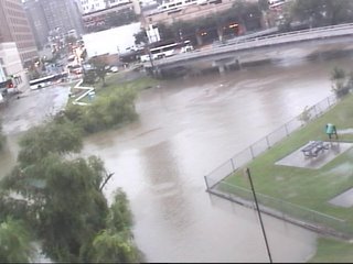
The rain came in early Sunday morning and we've had some periods of heavy rain with several breaks in between. Monday has been much worse with street flooding and several flood, flash flood and tornado warnings throughout the day. In my area we received 5+ inches, but parts of Houston have as much as 10 - 12 inches. Several schools are closed for the evening.

As of now the weather services are all predicting the portential for rain to decrease this evening and tomorrow should be partly cloudy.

================================================================

Tropical storm Norman has formed in the eastern Pacific and os heading for the southern tip of Baja California. From the NWS projections, it looks like this will be nothing more than a rain event. I'd be surprised if there is any damage except possibly some street flooding.

Keep an eye out for heavy rain in the southwestern US sometime around the end of next week. These areas have been inundated with rain this summer so flooding can be a big issue.

Friday, October 13, 2006

2006 Hurricane Season about over??


Courtesy: www.junkscience.com

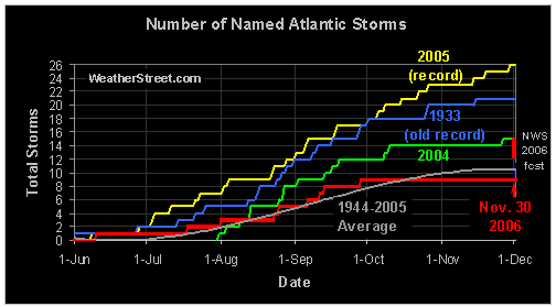
It appears the late season development of El Nino in the Pacific has just about squashed our fairly uneventful tropical season approximately six weeks before the season officially ends. There was a lot of hype about the possibility that a storm was going to form in the Carribean this week but that just fizzled.

Trackbacked to: Woman Honor Thyself, 123Beta

Wednesday, October 11, 2006

How and Where Hurricanes Form

This is a good overview of how hurricanes form and some information on their inner workings. (From LiveScience.com)

African Dust Storms and Atlantic Hurricanes

This is an interesting concept. Over the past 25 years a clear correlation between the dust storms coming off the Sahara Desert has an inverse relationship to the severity and frequency of the hurricanes that are formed. The greater the dust, the lower the storm severity or frequency.

The first half of this season when there were no hurricanes, the dust was essentially pouring off the African coast. When we saw a bunch of tropical storms build up during the middle of the summer, there was no dust. Apparently this trend has been occurring for quite some time according to satellite records. The only drawback to the trend is that when the dust is high, the tendency is for the storms to move further to the west thereby increasing the liklihood of landfall in the US. It seems to me that if the presence of the dust reduces the intensity of the storms, then the potential for landfall in the US is less of an issue.

One thing that is not mentioned in the article but to me seems to be a logical extension is the potential to use dust as a way to break apart storms before they develop into a high severity. Several technologies are being explored in an attempt to break apart hurricanes before they appraoch landfall. Maybe dumoing copious amounts of sand into the path of a tropical storm could help to diminish its severity and destructive potential.

Trackbacked to Woman Honor Thyself, 123Beta, Dumb Ox News

Tuesday, October 03, 2006

Drones to gather new hurricane data

This is really neat. I've seen a few articles calling for more research into hurricane formation and causes. NOAA's pilot project is to use military drones to gather data in the areas of a hurricane that are too dangerous for the hurricane hunter aircraft to venture. The entire project is budgetted for $300,000 for 5 drones, called Aerosondes which will be launched from a vehicle travelling at around 60 mph.

The Aerosondes have a 10 foot wingspan and are designed with the viewpoint that if they are lost then so be it. "If we lose the aircraft, that is part of the process," said Peter Bale, an Aerosonde representative.

Piloted "Hurricane Hunter" aircraft typically gather data at 10,000 feet. The Aerosondes will gather data from 500 ft of less over the surface of the ocean. The data will help meteorologists predict windspeed and storm intensity over land better.

Trackbacked to: Dumb Ox News, Woman Honor Thyself, Plancks Constant, 123beta, Diane's Stuff, Speed of Thought

Hurricane Season 2006 is slowing down

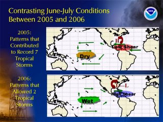
After all the dire predictions of how 2006 would be a very intense hurricane season with a high potential for a major hurricane hitting the east coast and possibly New York City, the year has basically turned out to be an average season.

The latest predictions are that we will see up to three more named storms with one possibly reaching hurricane strength but none are expected to affect land and they are expected to remain relatively mild.

I think there were two major effects that helped to lessen this year's storm season. 1. The area of high shear in the Gulf of Mexico and the Carribean remained in place far longer than had been predicted. 2. The typical Bermuda High that helps establish the steering currents that force the storms into the Gulf never formed this year. Instead we had alternating periods of low pressure systems off the east coast of the US or a stationary front that acted to block storms as they approached the US.

High pressure systems rotate clockwise in the northern hemisphere. As a storm approaches a high located around Bermuda the rotation of the high acts to convey the storm right into the Carribean Sea and either Central America or the Gulf of Mexico. This year the Bermuda High never formed. Instead there were many low pressure systems located along the east coast.

Low pressure systems rotate counter clockwise in the northern hemisphere causing the storms that did form this year to be driven north in the center of the Atlantic.

So with a combination of the high shear and the low pressures off the coast this year's hurricane season has essentially ended up being much ado about nothing.

Of course we all really know that it is actually Karl Rove's doing - that
he manipulated the weather to create a mild hurricane season to benefit the
Republicans in the mid-term elections :-)


Not quite ... and ... just as last year's season by itself in no way demonstrates a link between global warming and hurricane frequency and strength (as Al Gore's movie states), this year's does not disprove a link either. Next year could be another strong season and it may certainly be due to the Atlantic Multidecadal Oscillation the data for which is far more reliable than the data predicting man-made global warming.

Trackbacked to: Dumb Ox News, Woman Honor Thyself, Plancks Constant, 123beta, Diane's Stuff

2010 Atlantic Hurricanes (courtesy of Weatherstreet.com)

NOAA Gulf of Mexico Radar (courtesy of Weatherstreet.com)

NOAA West Atlantic & Caribbean Radar (courtesy of Weatherstreet.com)

NOAA East Atlantic Radar (courtesy of Weatherstreet.com)