Gulf Coast Hurricane Tracker

A single source reference on tropical weather predictions. With a traditional focus on the upper Texas and Louisiana Gulf Coast we've maintained links to track all Atlantic Basin, Caribbean and eastern Pacific storm systems. We are now expanding our view to tropical storms throughout the world intending to be a comprehensive global storm tracking resource.

Tuesday, September 28, 2010

TD # 16 forms in Caribbean; set to soak US East Coast

Tropical Depression 16 formed in the warm waters of the Caribbean yesterday and is now crossing much of Cuba. The storm seems to be fairly disorganized with much of the heavy rain far to the east of the center of the storm. Once this storm crosses the island, then increased organization is likely resulting in Tropical Storm Nicole.


Graphic courtesy of Spaghetti Models.com

The computer models show that this storm is set to soak the entire east coast over the next several days. Tomorrow the storm is projected to become a tropical storm and cross the Florida peninsula. From there the system will hug the coastline scraping along the entire eastern seaboard from South Carolina to the Canadian maritime provinces. From there the system or its remnants are projected to continue across the Atlantic over to the United Kingdom.

To me the storm track models look similar to an international flight plan from Atlanta to London. The models are very consistent with each other showign tight convergence along the coast. TD #16 is a fast moving storm and is projected to reach the Carolinas by Friday and New England by the end of the week.

Rainbands from TD#16 are already dropping moisture on Floriday. The rain will continue and become heavier as the storm approaches and crosses the southern end of the state.

Sunday, September 26, 2010

Matthew stalls; dumps heavy rain on Central America

Tropical Depression Matthew has become essentially stationary as it unloads it land over Central America. Matthew slammed ashore a few days ago in northern Nicaragua as a tropical storm. As the storm moves northwestward into Honduras, it degraded to a depression and slowed significantly.

Now Matthew is unloading all of the moisture it contains over an area that is already waterlogged due to a summer of heavy rainfall.

Weakened Matthew drenches parts of Central America(Lexington Herald Leader)
GUATEMALA CITY -- Matthew was drenching parts of Central America Sunday, a day after it weakened to a tropical depression.

The storm's forward movement was slowing as its top winds fell, meaning it could become nearly stationary somewhere over Mexico by late Sunday. Forecasters at the U.S. National Hurricane Center in Miami said the slow pace was going to allow the storm to produce rainfall totals of 6 to 10 inches over parts of Guatemala and southern Mexico. The rain threatened to cause flash floods and mudslides.

Forecasters say Matthew has maximum sustained winds of about 30 mph (45 kph), and is expected to continue losing strength. The storm's center was located about 85 miles (135 kph) southeast of Villahermosa, Mexico, early Sunday.

--snip--

In recent months, Guatemala has been hit by heavy rains that have resulted in about 274 deaths and about $1.1 billion in damage, according to government estimates.
Matthew was originally forecast to pass across Central America and re-emerge in the Gulf of Mexico and strengthen to hurricane status. Since the storm made landfall much futher south than ariginally forecast, the storm has been slowed significantly due to the moutainous terrain. It appears very unlikely that Matthew will have enough strength or forward motion to be able to survive as a storm and reach any water to allow restrengthening.

Friday, September 24, 2010

Tropical Storm Matthew forms; heads ashore

Graphic courtesy of Spaghettimodels.com

Tropical Storm Matthew developed yesterday afternoon in the Caribbean near the coast of Central America. The system had shown signs of orhanizing for several days but was depressed by high wind shear in the area. Once the wind shear died down, the system quickly developed, fueled by the warm Caribbean waters.

Initial storm track predictions showed Matthew strengthening over water and curving along the coast of Belize. Instead, Matthew made landfall in northeast Nicaragua. The storm is expected to cross Central America weakening as it moves across land.

Tropical Storm Matthew threatens Central America(Associated Press)
MANAGUA, Nicaragua — Nicaragua began evacuating thousands of people from the path of Tropical Storm Matthew as the storm drenched the Caribbean coast and threatened much of a Central American region prone to disastrous flooding.

The U.S. National Hurricane Center in Miami said Matthew's center was close to landfall Friday afternoon with maximum sustained winds of 50 mph (85 kph).

The Hurricane Center said it could bring 6 to 10 inches (15 to 25 centimeters) of rain to Nicaragua and Honduras, with the possibility of flash floods and mud slides. Some parts of Nicaragua already were coping with flooding due to earlier rains.

A tropical storm watch also was in effect for the coast of Belize.
Central America has had a heavy rainy season this year and the heavy rain from Matthew will increase the potential for flooding and landslides.
New storm threatens rain-soaked C. America(AFP)
Central America is facing one of the most intense rainy seasons in the last 60 years, with flooding and landslides that have killed more than 300 people and caused serious damage in recent months.

Matthew is forecast to make landfall near the Nicaragua-Honduras border late Friday or early Saturday, and authorities are bracing for more flooding as soil across much of the region is already saturated with water from the season's earlier storms.

--snip--

Matthew is expected to dump between six and 10 inches of rain over parts of Nicaragua and Honduras, with up to 15 inches possible in isolated areas.

"These rainfall totals may produce life-threatening flash floods and mud slides," the NHC said.

Tuesday, September 21, 2010

TSR Storm Alert - Hurricane IGOR to strike Canada

Tropical Storm Risk is reporting a 100% likihood that Hurricane Igor will strike the Canadian maritime provinces as a Category 1 hurricane. Igor appears on track to scrape the eastern edge of Newfoundland and the eye may even pass over or very close to the city of St. John's. The forecast calls for Igor to remain at hurricane strength as it progresses north past Newfoundland into Baffin Bay potentially brushing against the southwestern coast of Greenland or making landfall in the far northern areas of Nunavut Province.

Graphic courtest of Weather Underground

It is very unusual for a storm to remain this strong so far north. The computer models show a fair amount of scatter in the potential paths of the storm but it appears that Igor will likely enter Baffin Bay and make landfall in northern Canada as a tropical storm. There is a slight chance that Igor will head into the Northern Atlantic but this appears to be slim.

Graphic courtesy of Spaghetti Models.com

Hurricane Igor heads north, all the way to Greenland?(Christian Science Monitor)
Between next Thursday morning and Friday morning, forecasters at the National Hurricane Center in Miami say they expect Igor to make landfall on the southern tip of Greenland, perhaps with tropical-storm-force winds, then to move into the interior as a "post-tropical" depression.

The label "post-tropical" refers to a shift in a storm's energy source. In Igor's case, its energy source is expected to shift by Tuesday morning.

As a tropical cyclone, Igor draws its energy from heat. That heat is released as water condenses from vapor to cloud droplets as the vapor rises higher into the atmosphere and cools, forming powerful thunderheads. As the storm moves north, it encounters cooler water and draws its energy from the difference in temperature between the storm itself and a cooler mass of air sweeping into the North Atlantic from middle and high latitudes. At that point, Igor earns the post-tropical tag.

These storms can still be dangerous, since they continue to pack gale-force winds. These winds typically blow at altitudes of from several hundred feet to a little over 1,000 feet. They can trigger significant wind damage if the storm encounters an environment that encourages mixing between air layers near the ground and the layers carrying the gale-force winds.

By the time Igor draws even with southern Newfoundland overnight Tuesday, it is expected to pack hurricane-force winds, although it will have become post-tropical. Igor's track is expected to come close enough to the Canadian province's southeastern tip, prompting the government to issue tropical-storm warnings for that area.

N Atlantic: Storm Alert issued at 21 Sep, 2010 9:00 GMT


Hurricane IGOR (AL11) is forecast to strike land to the following likelihood(s) at the given lead time(s):
Red Alert Country(s) or Province(s)
Canada
probability for CAT 1 or above is 100% within 9 hours
probability for TS is 100% currently
Greenland
probability for CAT 1 or above is 35% in about 69 hours
probability for TS is 100% in about 33 hours
Red Alert City(s) and Town(s)
St John's (47.6 N, 52.7 W)
probability for CAT 1 or above is 100% within 9 hours
probability for TS is 100% within 9 hours

Yellow Alert Country(s) or Province(s)
St. Pierre and Miquelon
probability for TS is 100% currently
Yellow Alert City(s) and Town(s)
Grand Falls (48.6 N, 55.4 W)
probability for TS is 100% within 9 hours
Godthab (64.3 N, 51.6 W)
probability for CAT 1 or above is 10% in about 45 hours
probability for TS is 100% in about 45 hours

Note that
Red Alert (Severe) is CAT 1 or above to between 31% and 100% probability.
Yellow Alert (Elevated) is CAT 1 or above to between 10% and 30% probability, or TS to above 50% probability.
CAT 1 means Hurricane strength winds of at least 74 mph, 119 km/h or 64 knots 1-min sustained.
TS means Tropical Storm strength winds of at least 39 mph, 63 km/h or 34 knots 1-min sustained.

For graphical forecast information and further details please visit http://www.tropicalstormrisk.com/

This alert is provided by Tropical Storm Risk (TSR) which is sponsored by UCL, Aon Benfield, Royal & SunAlliance, Crawford & Company and Aon Benfield UCL Hazard Research Centre. TSR acknowledges the support of the UK Met Office.

Sunday, September 19, 2010

Typhoon Fanapi pounds Taiwan - heads to China

Typhoon Fanapi crossed Taiwan today bringing heavy rain, flooding and wind damage to the island. The storm killed three people when it slammed into the island and over 50,000 people are currently without power.

Video: Typhoon Fanapi hits Taiwan(ITN News)


Typhoon Fanapi rolls across Taiwan(UPI)
Fanapi killed at least three people when it hit Taiwan Sunday and left more than 50,000 people without power. The Category 3 storm whipped up winds of 123 mph and dropped nearly 8 inches of rain in Yilan and Hualien counties.

Police said a woman was killed when she fell into a river while doing last-minute harvesting ahead of the storm. Two students drowned in a flooded canal when a girl slipped and fell and two friends jumped in after her, CNN said.
The heavy rain prompted concerns of mudslides in the mountainous regions of the countryside, especially in isolated and remote areas.

Taiwan typhoon triggers fears of landslides(New Zealand Herald)
TAIPEI - Rescue crews rushed to evacuate people from mountainous regions vulnerable to landslides as a powerful typhoon hit Taiwan.

Typhoon Fanapi, the first major storm to strike the island this year, made landfall in the eastern city of Hualien on Saturday, packing winds of 162km/h and churning its way across the island at a speed of 20km/h, the Central Weather Bureau said.

Interior Minister Chiang Yoo Hoo ordered authorities to remove villagers from regions prone to landslides, mindful that torrential rains were likely to cause massive subsidence on mountainsides, particularly in isolated areas of Taiwan's south.
Fanapi slammed into central Taiwan at the equivalent of a Category 3 on the Saffir-Simpson scale. Once it struck land it turned to the south and then crossed the southern portion of the island before emerging into the Taiwan Strait at a Category 1 strength. The storm is expected to remain at a Category 1 strength as it crosses the water and makes landfall in Fujian Province.

China Prepares for Typhoon Fanapi(VOA News)
China has stepped up emergency measures as typhoon Fanapi approaches its southeastern coast.

Weather officials have raised the typhoon to the second highest alert level. The government has said Fanapi could be the strongest storm to hit China this year.

Authorities in southeastern Fujian province ordered fishermen to stay away from the coast. More than 186,000 people have been evacuated, and many businesses shut down Sunday.
Three previous typhoons have struck this same region this year.

Hurricane Igor Batters Bermuda

After becoming the most ferocious hurricane in the Atlantic this year, Hurricane Igor diminished to a CAtegory 1 hurricane just prior to reaching landfall in Bermuda. Even with the weakened wind speed, Igor is a very large storm with hurricane force winds extending wider than the size of the island.

Video: Raw Video: Igor Surge Blasts Bermuda(Associated Press)


Hurricane Igor pounds Bermuda (Right Juris)
Bermuda braces for Hurricane Igor. Now downgraded to a Category 1 hurricane, Igor is closing towards Bermuda with sustained winds of 85 MPH. Hurricane Igor is currently about 100 miles SSW of Bermuda moving north at 16 MPH. The large storm is already pounding the island with heavy rain, wind and waves. The National Hurricane Center in Miami anticipates Bermuda being affected by Igor well into Monday.

Hurricane Igor may have weakened but it is still a monster due to it’s sheer size. Hurricane force winds of 75 MPH or more extend nearly 90 miles out from it’s center. Tropical storm conditions extend out over 300 miles.
Igor is expected to pass directly over Bermuda with the eye of the hurricane passing over the island Sunday evening.

Hurricane Igor lashes Bermuda(CBC News)
Hurricane Igor is lashing Bermuda with heavy rain and high winds, forcing islanders to board up windows, fill sandbags and stock up on emergency supplies.

The eye of Igor was expected to pass near or over Bermuda on Sunday evening, the U.S. Hurricane Center said. At 2 p.m. AT on Sunday, Igor was 185 kilometres south-southwest of Bermuda with maximum sustained winds of 140 km/h.

The hurricane, which was downgraded to a Category 1 storm overnight, could produce as much as 23 centimetres of rainfall.

A dangerous storm surge was expected to produce significant coastal flooding on the island. The surge will likely be accompanied by large and destructive waves, particularly along the southern coast, the forecaster said.

Friday, September 17, 2010

Hurricane Karl swells to monster;slams Mexico

Hurricane Karl quickly grew from a Cat 1 hurricane to a Cat 3 hurricane within 24 hours yesterday and last night. Karl is the third major hurricane in the Atlantic basin and the third to grow so quickly. Igor and Julia also grew from a Category 1 to a Category 4 very quickly with both storms existing as Category 4 storms simultaneously in the Central Atlantic.

Karl came ashore with 125 MPH winds this morning and is slowly decreasing in strength.

Powerful hurricane Karl hits Mexican Gulf coast(CTV)
VERACRUZ, Mexico — Hurricane Karl smashed into Mexico's Gulf Coast on Friday, creating havoc in the major port city of Veracruz and forcing the country to shut down its only nuclear power plant and its central Gulf Coast oil platforms.

The U.S. National Hurricane Center in Miami said Karl's eye hit about 10 miles (15 kilometres) northwest of Veracruz at about 11:30 a.m. (12:30 EDT; 1630 GMT) with sustained winds of 115 mph (185 kph).

Veracruz civil protection chief Isidro Cano Luna said the storm already had caused widespread damage, knocking down trees, billboards and power poles. He said there had not been a storm like it since Hurricane Janet hit in September 1955.

While the storm is expected to weaken as it moves inland, it was still likely to be at hurricane force when it reaches the state capital of Jalapa, 60 miles (100 kilometres) from the coast, said that city's Mayor David Velasco Chedraui.

It was projected to slog across central Mexico, drenching Mexico City, after dumping heavy rain into the mountainous, flood-prone region of Veracruz where a storm killed more than 300 people in 1999, most in landslides.
Video: Karl Now a Category 3, Bermuda in Igor's Path (Associated Press)

Thursday, September 16, 2010

Karl enters the Gulf; becomes a hurricane

After crossing the Yucatan peninsula as a tropicals storm, Hurricane Karl grew to a Category 1 hurricane with sustained wind speed of 75 MPH. Karl is expected to continue intensifying and will likely be a Categoy 2 storm before making landfall on the Central Mexican coast.

Hurricane Karl takes aim at Mexican Gulf coast(Associated Press)
VERACRUZ, Mexico — Karl reached hurricane force in the Gulf of Mexico on Thursday after dumping heavy rain on the Yucatan Peninsula. It was expected to strengthen more before hitting Mexico's coast near a port and an oil hub late during the night or early Friday.

The U.S. National Hurricane Center in Miami, Florida, said there was a possibility that Karl could become a major hurricane with winds of 110 mph (175 kph) or higher before making landfall.

The Mexican government issued a hurricane warning for a 150-mile (250-kilometer) stretch of coast in Veracruz state. On its predicted path, Karl could make landfall near the coastal city of Tuxpan and the oil hub of Poza Rica.

Authorities in Veracruz — whose southern half has been battered by severe flooding over the past few weeks — prepared for a hit on its northern coast, getting ready sleeping mats, bottled water and other supplies for anyone needing to take refuge in shelters.

Workers in the port city of Veracruz cut dangerous tree limbs and inspected billboards to make sure they would not become flying debris if the hurricane hit.

By early Thursday, Karl was about 310 miles (500 kilometers) east of Tuxpan, with winds of 75 mph (120 kph). It was moving westward rapidly at about 12 mph (19 kph).
Karl is expected to strengthen and may even become a major hurricane. It is expected to produce very heavy surf as it slams into the Mexican coast with a storm surge as high as 9 feet above normal levels.

Hurricane Karl churns in the Bay of Campeche(NOLA)
Reports from an Air Force Reserve hurricane hunter aircraft indicate that maximum sustained winds have increased to near 75 mph with higher gusts. Karl is a Category 1 hurricane on the Saffir-Simpson hurricane wind scale. Additional strengthening is likely and Karl could approach major hurricane strength before the center reaches the Mexican coast.

Hurricane force winds extend outward up to 10 miles from the center and tropical storm force winds extend outward up to 70
miles. Minimum central pressure just reported by the hurricane hunter is 983 mb.

A dangerous storm surge will raise water levels by as much as 6 to 9 feet above normal tide levels along the immediate coast near and to the north of where the center makes landfall. Near the coast the surge will be accompanied by large and destructive waves. Within the hurricane warning area tropical storm conditions are expected by Friday with hurricane conditions expected by late Friday and Friday night.

Karl is expected to produce rainfall accumulations of five to 10 inches across the central and southern Mexican Gulf Coast region with isolated amounts of 15 inches possible in the interior mountains. These rains could cause life-threatening flash floods and mud slides.

Wednesday, September 15, 2010

Hurricane Julia explodes to Cat 4

Yesterday, in the span of only an hour or two, Julia jumped from a Category 1 hurricane with winds of around 85 MPH to a Category 4 hurricane with winds over 130 MPH. Julia remained at Cat 4 strength for much of today and is just now dropping in strength to a Cat 3. Currently, Julia has windspeeds of 125 MPH (and gusts of 155 MPH) and dropping. Hurricane Igor is remaining steady with windspeeds of 135 MPH (with gusts as high as 160 MPH).

Having two major hurricanes side by side in the Atlantic in very rare, especially two storms of such massive intensity. The last time this occurred was in 1926.

Hurricane Igor, Julia Made History Wednesday(AccuWeather)
At 5 a.m. Wednesday, Hurricane Julia was upgraded to a Category 4 storm, while her brother, Hurricane Igor, maintained his Category 4 status.

In doing so, Julia also became the strongest hurricane on record so far east.

Although the storm was downgraded to a Category 3 at 5 p.m., this 12-hour period marks only the second time in recorded history that two Category 4 hurricanes were active at the same time in the Atlantic.

The other time this occurred was in September 1926. As modern storm naming was not in practice back then, Hurricane Four began on Sept. 2, and this slow-moving storm lasted about 22 days total. This storm remained at sea and did not make landfall in the United States.

During this time, Hurricane Six developed in the Atlantic and strengthened into a Category 4 storm. The storm remained at Category 4 as it made landfall on Sept. 18, hitting Miami directly.

Video: Igor, Julia and Karl All Making Waves(The Associated Press)

Tropical Storm Karl Strikes Yucatan

Tropical Storm Karl made landfall this morning on the Yucatan peninsula near the Mexico/Belize border. Karl had winds as high as 65 MPH and hot as a strong tropical storm. It is expected to weaken as it crosses the Yucatan today. Once re-emerging in the Bay of Campeche, Karl will strengthen once again.

UPDATE 1-Tropical Storm Karl makes landfall in Mexico(Reuters Africa)
MEXICO CITY, Sept 15 (Reuters) - Tropical Storm Karl made landfall near Chetumal, Mexico, on Wednesday and was expected to steer west across the Yucatan peninsula to re-emerge in the southern Gulf of Mexico close to oil fields in the Campeche sound.

Karl, the 11th named storm of the season, had winds of 65 miles per hour/(100 kph) with higher gusts as of 7:45 a.m./(1245 GMT). Its center was expected to cross the Yucatan on Wednesday and re-enter the Gulf of Mexico after nightfall.

"Restrengthening is forecast on Thursday after Karl moves over the southwestern Gulf of Mexico where Karl is likely to become a hurricane," the U.S. National Hurricane Center said.

Upon reaching water again, Karl was likely to miss U.S. oil and natural gas rigs in the northern part of the Gulf although forecasters said it may hit Mexican oil rigs.

Tuesday, September 14, 2010

Tropical Storm Karl forms in the Caribbean

An area of disturbed tropical weather in the Caribbean finally organized enough today to become Tropical Storm Karl. Karl currently has 45 MPH winds and is expected to gain strength before slamming into the Yucatan Peninsula as a strong tropical storm. Water temepratures are quite warm in the western Caribbean and wind shear is low. Higher wind shear prevented Karl from forming as it crossed the Caribbean.


Tropical Storm Karl forms in Caribbean(Associated Press)
MIAMI — Tropical Storm Karl has formed in the northwestern Caribbean, heading on a path expected to take it over the Yucatan Peninsula.

Forecasters say the storm has maximum sustained winds of about 40 mph (65 kph) and is located about 270 miles (435 kph) east of Chetumal, Mexico. It's moving west-northwest at 15 mph (24 kph).

Mexico's government has issued a tropical storm warning for the peninsula from Chetumal northward to Cabo Catoche. Parts of Belize are under a tropical storm watch.

The U.S. National Hurricane Center in Miami says the storm is expected to strengthen, and its center could be over the Yucatan on Wednesday.
There are now three tropical systems in the Atlantic Basin. Two hurricanes, Igor and Julia and TS Karl in the Caribbean. Igor was the strongest hurricane in the Atlantic this year and is strengthening again. Of the three, Karl is an immediate threat to land as it approaches Mexico. Igor will be a threat to Bermuda as a strong Cat 2 or potentially a Cat 3 storm by the weekend.

Three Tropical Cyclones Tracked in Atlantic by National Hurricane Center(Bloomberg)
For the third time in less than a month, the National Hurricane Center is tracking three storms in the Atlantic.

Hurricanes Igor and Julia are spinning their way through the central Atlantic, while newly formed Tropical Storm Karl heads for Mexico’s Yucatan Peninsula and from there into the Bay of Campeche, where state oil company Petroleos Mexicanos has wells.

“I expect Karl to become a low-end hurricane as it tracks across southern and central portions of the Bay of Campeche,” said Jim Rouiller, senior energy meteorologist for Planalytics Inc. in Berwyn, Pennsylvania. “The Mexican rigs and platforms will probably be shut in.”
Video: Two Hurricanes Now Churning Through Atlantic (Associated Press)

Intense Hurricane Igor begins turn northward

Hurricane Igor began a turn to the north last night after travelling westward across the Atlantic for several days. Igor's northwesterly direction now means that the Leeward Islands will be spared a direct hit from this intense storm. Igor's windspeed has dropped somewhat but it is still a dangerous Category 4 storm.

Igor's path now takes it directly towards Bermuda. Igor is expected to remain a major hurricane until the middle of the weekend when it will drop to a strong Category 2 storm as it passes over the island. A slight shift in Igor's path could make the difference between a bad weather event or an extreme pounding.

`Dangerous' Igor Heads Toward Bermuda as Hurricane Julia Forms to the East(Bloomberg)
Hurricane Igor, the season’s most powerful storm, headed toward Bermuda on a track that may threaten the island group this weekend, while Julia became the fifth hurricane of the season today over the eastern Atlantic.

Igor was still a “dangerous” Category 4 storm, the second strongest on the 5-step Saffir-Simpson scale, after its winds dropped to 135 miles (215 kilometers) an hour from 150 mph yesterday, the National Hurricane Center said on its website at 4:45 a.m. Miami time. The storm was 750 miles east of the Caribbean’s Leeward Islands heading west-northwest at 8 mph.

Both Igor and Julia, with 75 mph winds behind it, are forecast to head into the north Atlantic while a collection of thunderstorms in the Caribbean is predicted to move west into Mexico and avoid the Gulf of Mexico, which accounts for 31 percent of the U.S. oil output, computer models show.

“Swells generated by Igor will begin affecting the Leeward Islands today and will reach Puerto Rico and the Virgin Islands tonight and Wednesday,” the center said. “These swells are likely to cause life-threatening surf and rip current conditions.”

The center’s prediction map shows Igor weakening while heading almost directly for Bermuda early on Sept. 19. Tropical Storm Risk, a London-based venture that grew out of a U.K. government-supported tsunami initiative, gives the islands a 10 percent chance of being struck by a hurricane bearing winds of at least 74 mph within five days.

Hurricane Julia forms in the Atlantic

Tropical Storm Julia formed off the coast of Africa a couple of days ago. After passing the Cape Verde Islands as a tropical storm, Julia grew to a Category 1 hurricane and tunrd towards the northwest.


Hurricane Julia is expected to remain a Category 1 storm until the weekend when it becomes a tropical storm once again in cooler waters. The storm is currently not expected to affect land at all, but will likely die out in the central Atlantic as it moves north.

Sunday, September 12, 2010

Igor explodes to Category 4 hurricane

Graphic courtesy of Weather Underground

Hurricane Igor grew from a tropical storm to a Category 1 hurricane yesterday. The storm was moving out of a region with high wind shear into an area where the wind shear is very low or non existant and the sea surface temperatures are very warm. As a result this morning Igor grew to a Category 2 and by early afternoon exploded into a Category 4 monster.

The NHC is reporting that Igor has 135 MPH sustained winds with gusts as high as 160 MPH. Igor is moving ratehr quickly through the Atlantic at 14 MPH.

Igor Rapidly Intensifies into Category 4 Hurricane(AccuWeather)
Igor became the fourth hurricane of the season Saturday evening as it headed farther west over the open waters of the Atlantic. The storm has since intensified rapidly, reaching powerful Category 4 status Sunday afternoon.

While minor fluctuations in intensity can occur, the storm is expected to generally remain a major hurricane through much of the upcoming week.

Most computer models show Igor curving slightly northward over the western Atlantic in the next few days, steering clear of the Leeward Islands but posing a major threat to Bermuda next weekend.

While the storm may very well follow this type of track, there is still a small chance that it heads farther west, drawing nearer to the Leeward Islands and making its northward curve closer to the East Coast of the United States.

The forecast calls for Igor to generally remain a major hurricane well into the weekend. It is expected to curve towards Bermuda but the track can still shift more towards the west. Coastal regions may encounter rough surf and rip tides and the storm may even approach the eastern US. The threat to the eastern US will be better defined by mid week.

Thursday, September 09, 2010

TSR Storm Alert - Typhoon MERANTI slamming into Chna

Typhoon Meranti has been upgraded to a Category 1 typhoon today and is currently making landfall along the China coast. Meranti brought heavy rain to Taiwan yesteray inundating villages in southeastern Taiwan with 10 - 20 inches of rain.
 
The latest Pacific tropical cyclone, Meranti, has poured torrential rain over southern Taiwan as it twirls toward southeastern China as a typhoon.
 
As of Thursday morning, EDT, rainfall of 10 to 20 inches had already inundated southeastern Taiwan, with Taitung having accumulated at least 13.0 inches.
 
Meanwhile, Meranti, now upgraded to a typhoon, was centered about 200 miles southwest of Taipei, Taiwan. Having highest sustained winds of 75 mph, Meranti was spinning northward at 10 to 12 mph.
 
Meranti was on target for a landfall upon southeastern China near Quanzhou, in Fujian, by early Friday morning, EDT.
Multiple sources Thursday indicated that five villages in Taiwan were evacuated in reaction to the excessive rainfall and runoff.
On Thursday Taiwan issued a land and sea warning as the northeast quantrant of the typhoon brushed against the southwest corner of the island.
 
TAIPEI, Thursday 9 September 2010 (AFP) - Taiwan Thursday issued a warning against tropical storm Meranti, urging residents to take precautions as the weather system could bring severe downpours as well as flooding and landslides.
 
The warning was especially for residents of Penghu, an island group in the middle of the Taiwan Strait, and Kinmen, another archipelago near southeast China's Fujian province.
 
The two island groups might be hit by the storm if it continued on its current track, the Central Weather Bureau said.
At 03:00 GMT, Meranti was about 180 kilometres (110 miles) west of the southern-most tip of Taiwan, the bureau said.
 
It was moving north-northwest at speed of 15 kilometres per hour and may make landfall in Fujian Friday, according to the bureau.
As the alert below states, Typhoon Meranti is currently making landfall in Fujian province near Quanzhou as a Cat 1 typhoon.
NW Pacific: Storm Alert issued at 9 Sep, 2010 18:00 GMT
 
Typhoon MERANTI (11W) is forecast to strike land to the following likelihood(s) at the given lead time(s):
Red Alert Country(s) or Province(s)
    China
        probability for CAT 1 or above is 100% currently
        probability for TS is 100% currently
Red Alert City(s) and Town(s)
    Quanzhou (25.0 N, 118.5 E)
        probability for CAT 1 or above is 90% within 12 hours
        probability for TS is 60% currently
    Putian (25.6 N, 119.0 E)
        probability for CAT 1 or above is 65% within 12 hours
        probability for TS is 65% within 12 hours

Yellow Alert City(s) and Town(s)
    Fuzhou (26.1 N, 119.3 E)
        probability for CAT 1 or above is 20% within 12 hours
        probability for TS is 40% within 12 hours

Green Alert City(s) and Town(s)
    Zhangzhou (24.5 N, 117.8 E)
        probability for TS is 40% currently

Note that
    Red Alert (Severe) is CAT 1 or above to between 31% and 100% probability.
    Yellow Alert (Elevated) is CAT 1 or above to between 10% and 30% probability, or TS to above 50% probability.
    Green Alert (Low) is TS to between 31% and 50% probability.
    CAT 1 means Typhoon strength winds of at least 74 mph, 119 km/h or 64 knots 1-min sustained.
    TS means Tropical Storm strength winds of at least 39 mph, 63 km/h or 34 knots 1-min sustained.

For graphical forecast information and further details please visit http://www.tropicalstormrisk.com/

This alert is provided by Tropical Storm Risk (TSR) which is sponsored by UCL, Aon Benfield, Royal & SunAlliance, Crawford & Company and Aon Benfield UCL Hazard Research Centre. TSR acknowledges the support of the UK Met Office.

Wednesday, September 08, 2010

Another tropical storm to hit South China

A new tropical storm has formed in the South China Sea and is heading for the Chinese province of Guangdong. This storm is moving steadily towards the coast and is expected to make landfall between Hong Kong and Zhangzhou.
Tropical storm heading for south China(China Daily)
BEIJING - The 10th tropical storm to hit China this year is expected to land in southern coastal regions between Thursday evening and midday Friday, the country's meteorological authorities warned Wednesday.

The China Meteorological Administration (CMA) National Meteorological Center said the storm, which formed in the South China Sea Wednesday, was moving westward with wind speeds of 10 to 15 kilometers an hour at its eye.

It was expected to gain strength and become more powerful before landing at the east of Guangdong Province and the south of Fujian Province, said the meteorological center.

Tropical Storm Igor forms near Cape Verde Islands

Tropical Storm Igor formed in the far east Atlantic Ocean just south of the Cape Varde Islands. The storm will bring tropical storm conditions to the islands later tonight and tomorrow. It is slowly increasing in intensity and is expected to become a hurricane by the end of the week.

Tropical Storm Igor forms in the Atlantic(Examiner)
A tropical storm has formed in the Atlantic, off of Cape Verde, Western Africa. This tropical storm, named Igor, is forecast to become a hurricane before the start of the weekend, heading west toward the Lesser Antilles next week.

The system has wind speeds of of 45 mph at the current time and is moving west at 6 mph. This is the speed of a sprint on a racetrack or a light jog.

Current long term projections call for Igor to follow a path similar to that of Hurricane Danielle a few weeks ago. A front is expected to cross the US pushing the remnants of Hermine to the east and then steer the path of Igor to the north possibly towards Bermuda.

Hermine continues to pound North Texas

Heavy rain continues to fall across Central and North Texas driving total rainfall amounts to very high levels. Flooding in many areas has resulted in several high water rescues and road closures.

Excessive rain from "Hermine" floods roads in Metroplex; Rain totals UPDATED(Examiner)
Rainfall totals have been rapidly moving upwards thanks to heavy bands of rain associated with the circulation of Tropical Depression Hermine.

--snip--

There were also some stronger storms which formed in a spiral band associated with Hermine. A 65mph wind gust was reported in Seagoville around lunch time.

This rainfall will continue on and off overnight with a sharp drop in precipitation coverage and intensity by tomorrow.
Several severe storms have been spawned in some of the rainbands left over from Hermine. Wind gusts as high as 65 MPH were observed in one town and 4 tornadoes were seen within the Dallas Metroplex.

Tornadoes touch down in Dallas (CNN)
Dallas, Texas (CNN) -- At least four tornadoes spawned by Tropical Depression Hermine touched down in and around Dallas, Texas, on Wednesday evening, sending up debris and swirling around buildings.

Sirens went off in downtown Dallas as one funnel cloud was spotted in Cockrell Hill southwest of downtown, according to CNN affiliate WFAA.

One tornado was reported in Ellis County and three in Dallas County, according to CNN meteorologist Taylor Ward.

--snip--

Forecasters had said most parts of central and eastern Texas and Oklahoma could receive 4 to 6 inches of rain, but the numbers for some parts of Texas were staggering.

Before the bulk of the storm moved out of Texas, Georgetown had received 13.2 inches of rain Wednesday, according to the National Oceanic and Atmospheric Administration's Hydrometeorological Center. Cedar Park had received 12.9 inches; Anderson Mill, 12.7 inches; Killeen, 11.6 inches; and Austin, 11.4 inches. Fort Worth had recorded 6.8 inches of rain, San Antonio, 6.7 inches and Houston, 4.4 inches.

Aerial images showed scores of flooded streets and some rescues in Dallas.

Portions of Austin had endured 15 inches of rain, and a middle-age motorist was missing after her car was washed away, Emergency Management spokeswoman Reyne Telles said. The car was found.

Thirty-two roads were closed, and an engineer from the watershed department said this could be a 250-year event, Telles told CNN.
The remains of Hermine are spread across four states with the heaviest storms in North Texas, Oklahoma, and Arkansas and is spreading north into southwest Missouri and southeast Kansas.

Tuesday, September 07, 2010

Hermine reaches Central Texas as a tropical storm

Tropical storm Hermine remained a tropical storm as it moved into Texas today. As of this afternoon, the center of the storm was clearly visible on radar and windspeeds were still above the 39 MPH required to classify the system as a tropical storm.

Heavy rain, thunder and lightning covered much of the area from Galveston to Texarkana and Dallas to San Antonio. Rainfall may be excessive and record setting in many areas and flooding is a concern for the next couple of days.

Flash flood watches, warnings issued across Central Texas(News 8 Austin)
Though all coastal tropical storm warnings were discontinued Tuesday afternoon, Central Texas has at least another day to soak up the damp spin-off.

Around 6 p.m. Tuesday, a tornado warning was issued for eastern Travis County and part of Williamson and Burnet counties. The NWS reported a funnel cloud was spotted just south of Manor, but there were no other reports of a tornado. The warning was canceled around 7 p.m.

--snip--

Tropical Storm Hermine made landfall Monday, causing more than 30,000 electrical outages in the Brownsville-Harlingen area, as it moved over the Rio Grande and into South Texas. Expected to weaken into tropical depression by Tuesday night, Hermine moved between San Antonio and Austin Tuesday afternoon, shedding heavy rain and high wind gusts in the area.

The National Weather Service advises that heavy rains could cause flash flooding, and notes that isolated tornadoes are possible over portions of southeast and central Texas Tuesday. McLennan County is one of the areas under tornado watch.

"Hermine is expected to produce total rainfall accumulations of 4 to 8 inches with possible isolated maximum amounts of 10 inches, from the middle Texas coast northward through Central Texas, and over central and eastern Oklahoma," according a NWS public advisory."

Rain totals may exceed 2 to 3 inches in some areas. Portions west of Austin could see as much as 5 to 7 inches of rain, and areas from west Travis County to Burnet County could very well see the worst of it, starting at sunset Tuesday and ending at sunrise Wednesday.
A tornado watch has been in place from the coast into the Hill Country essentially covering a rectangle that was bisected by IH-45.

Tornado watch issued for much of Dallas-Fort Worth(Dallas Morning News)
Rainfall totals exceeded 2 inches in many locations today — about what Dallas-Fort Worth can expect in an entire September — with chances for more heavy storms lingering Wednesday and much of the day Thursday.

A tornado watch is in place until 8 p.m. tonight for the following counties: Collin, Dallas, Denton, Hunt, Kaufman , Parker, Rockwall, Tarrant and Wise.

Hermine came ashore near the Texas-Mexico border on Monday and took a northerly swing that carried the center of the storm over San Antonio, just west of Austin and up into the Hill Country. That track should take the heart of the storm well west of the Dallas area Wednesday.

"We see it heading toward Abilene, and driving copious amounts of moisture along both sides of the Interstate 35 corridor,” said Joe Harris, a meteorologist with the National Weather Service in Fort Worth. “It means rain, chances of tornadoes, and gusty winds into Thursday.”
Around 5 pm CDT Hermine finally started to break apart and was downgraded to a tropical depression. The storm is spreading its energy and rainband across the eastern half of the state. Rainfall as high as 8 inches is possible in teh northern areas of Texas, through the central portion of Oklahoma and into Kansas.

Graphic courtesy of The Weather Channel

Tropical Storm hermine makes Landfall

Tropical Storm Hermine came ashore in northern Mexico late Monday night, quicjkly crossing the border into Texas. As the radar shows, this storm is pumping massive amounts of heavy rain into central and northern Texas from the Gulf.

Hermine struck land with 65 MPH sustained winds. The stoprms windspeed will slowly decrease as the day progresses and the storm will become a tropical depression

Tropical Storm Hermine Crosses Into Texas(Fox News)
Hermine made landfall in northeastern Mexico late Monday and crossed into Texas within hours, bringing with it winds of up to 65 mph (100 kph). It moved on a path similar to the one Hurricane Alex took in late June, and like that Category 1 storm, threatened to dump up to a foot of rain in some areas and cause flash flooding.

Hermine was no Alex in terms of strength. But Hermine wasn't taken lightly: Mexican emergency officials in Tamaulipas worked to evacuate 3,500 people around Matamoros, across the border from Brownsville, Texas, and schools on both sides of the border canceled classes Tuesday.

By early Tuesday, the center of the storm had crossed the Rio Grande River. The National Hurricane Center said the storm was about 10 miles (15 km) south-southwest of Harlingen, Texas, and 20 miles (30 km) northwest of Brownsville. It was moving north-northwest at 14 mph (22 kph).

A tropical storm warning was in effect from Rio San Fernando, Mexico, north to Port O'Connor, Texas.
Video: Tropical Storm hermine soaks South Texas (Associated Press)


Hermine will soak most of Texas all the way up through Dallas with potentially as much as a foot of rain. The stronger, wet side of this storm is acting as a pump bringing moisture up from the Gulf in heavy sheets of rain and thunderstorms. Flash flood watches and warnings are in effect. People need to take shelter from the flooding which has the potential to be quite severe.

Rain from Tropical Storm Hermine to give Dallas days-long soaking(Dallas Morning News)
Mexico may be bearing the brunt of Tropical Storm Hermine today, but she’s making her presence felt in North Texas, too.

"We are going to be on the wet side of Hermine," said Nick Hampshire, a meteorologist with the National Weather Service in Fort Worth

--snip--

Hermine made landfall in Mexico early this morning and quickly made its way into Texas with harsh winds and rainfall.

A flash flood watch is in effect through Thursday morning for the Dallas area, which is expected to experience rain through Wednesday night.

"There may be a few brief periods were the rain will stop," Hampshire said, "but we will mostly see light to moderate rain with a few embedded heavier showers."

Hermine's wet wrath should end by Wednesday evening as the storm tapers off, but rain remains in the forecast through Thursday.

Monday, September 06, 2010

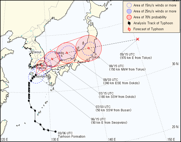
Tropical Storm Malou impacts Korea

Graphic courtesy of Korea Meteorological Administration

After being battered by Tropical Storm Kompasu last week, another tropical storm takes aim on South Korea, this time at the southern end of the peninsula. Malou has been moving generally northward as a tropical storm throughout the past week bringing heavy rain to eastern China but otherwise not impacting land.

Malou is now crossing the island of Jeju where a typhoon warning is in place. The storm will cross the southern end of the peninsula very close to or directly over the city of Pusan.

Tropical Storm Malou Churns Toward South Korea as Typhoon Warning Issued(Bloomberg)
Tropical Storm Malou headed toward South Korea, where five people died when a cyclone struck last week, the U.S. Navy Joint Typhoon Center said.

Malou was 122 kilometers (76 miles) south of Jeju at 9 a.m. Seoul time today, the center said. The storm is forecast to hit the island before crossing southern regions of the country tomorrow, the center said.

The storm had sustained winds of 74 kilometers per hour and Malou is expected to maintain strength as it reaches Jeju about 3 p.m. local time today, the center said.

The Korea Meteorological Administration issued a typhoon warning for Jeju and surrounding seas, and a heavy rain watch for Ulsan in the southeast of the country, it said on its website.


After brushing against Korea, Malou will continue on and cross Japan north of Tokyo in a couple of days.

Tropical Storm Hermine forms; Heading for Central and South Texas


Radar courtesy of Weather Underground

Tropical Storm Hermine formed in the southern Gulf of Mexico and currently has winds of 50 MPH with gusts as high as 65 MPH. The radar is showing that rain from this storm is already coming ashore in south Texas. As the storm moves onshore, the forecast is that South and Central Texas will be hit with heavy rain with a good potential for flooding.

Hermine's Flood Danger, Even Well After Landfall(AccuWeather)
Bands of drenching rain will increase across northeastern Mexico and southern Texas into this afternoon as Hermine approaches. Any heavy bursts of rain could trigger localized flash flooding.

Steadier and heavier rain will pour down across southern Texas and northeastern Mexico tonight into Tuesday as Hermine moves inland. By the end of Tuesday, these areas will be inundated by 4 to 8 inches of rain with localized amounts of up to a foot.

Flooding will quickly ensue in low-lying and poor drainage areas. Small streams and creeks will rise rapidly and overflow their banks. Residents, especially those in flood-prone areas, should spend today planning for possible evacuation orders.

Officials may be forced to close roads that become inundated with flood waters.

Even if barricades are not in place, motorists are reminded never to drive through a road covered in water. The roadway underneath may be washed away or the water's swift current could sweep away your vehicle.

The danger of flooding in southern Texas and northeastern Mexico will persist several days after Hermine departs. Similar to what occurred in the wake of Hurricane Alex, the Rio Grande River will eventually rise as the flood waters drain downstream.

As the river becomes swollen, neighboring land and communities will be at risk for flooding.
The computer models all seem to be quite well aligned converging on landfall just south of Brownsville, TX. Once onshore the storm will curve towards the north spreading heavy rain across central Texas for several days even after it loses Tropical Storm status.


Graphic courtesy of Spaghettimodels.com

A tropical storm warning is in place from Tampico to the mouth of the Rio Grande in Mexico and then From the Rio Grande to Port O'Connor in Texas. A hurricane Watch is in effect from Rio San Fernando, Mexico to Baffin Bay, Texas (source: Weather Underground)

Tropical Storm Hermine gaining strength in Gulf
(KHOU)

MIAMI -- Tropical Storm Hermine is getting a little stronger in the Gulf of Mexico as it heads toward the coasts of Texas and Mexico.

A tropical storm warning was issued early Monday for the southern Texas coast. A tropical storm warning was already in effect for the coast of Mexico from Tampico to the mouth of the Rio Grande.

Hermine’s maximum sustained winds have increased to near 45 mph (75 kph) with some additional strengthening expected before the storm makes landfall.

Heavy rain is predicted with northeastern Mexico into south Texas getting 4 to 8 inches with as much as a foot in some places. It could cause flash floods and mudslides.

Friday, September 03, 2010

Developing tropical systems

Several storms are developing in both the Atlantic and the Pacific basins.

Tropical Storm Gaston disintegrated into a remnant low pressure system over the past few days from a Tropical Storm due to interactions with dry air and wind shear. Today these remnants have been reorganizing and the NHC is projecting a 60% chance that Gaston will re-develop into a tropical depression or tropical storm within the next 48 hours.

To the east of Gaston's remains is a rather vigorous tropical wave that is showing signs of organizing near the Cape Verde Islands. The NHC has increased the likelihood of organization to 30% this evening.

In the Eastern Pacific, two tropical depressions have formed along the coast of Mexico.

Tropical Depression 10E has 35 MPH sustained winds. It is located to the southwest of Baja California and is moving away from land. The system is not expected to strengthen and is only a concern for shipping interests.

Tropical Depression 11E is located near the southern coast of Mexico. It also has 35 MPH winds and is moving towards the southern Mexican coast. It is expected to become a Tropical Storm before making landfall. Once it makes landfall, the computer models show several pathways all of which take the storm up through Mexico. There is a very slight chance that the system could enter the Gulf and re-develop.

Tropical Storm Fiona degrades; no threat to Bermuda

Tropical Storm Fiona continually battled wind shear coming off Hurricane Earl throughout its trip from the Leeward Island northward in the central Atlantic. Fiona struggled to retain its Tropical Storm status and succeeded until tonight's hurricane update. Fiona now has winds of 35 MPH and is a tropical depression.

Fiona is moving just to the east of Bermuda and is lashing the island with winds of just at or below minimal tropical storm strength. A tropical storm warning has been cancelled but a small craft advisory is in effect through Saturaday.

Residents and visitors should still be cautious as there could be strong thunderstorms associated with the remnants of Fiona.


Fiona weakens to a tropical depression in Atlantic(Associated Press)
MIAMI — To the southeast of Earl in the Atlantic, Fiona is weakening and has become a tropical depression as it heads toward Bermuda.

The U.S. National Hurricane Center in Miami said Friday that Fiona had maximum sustained winds of 35 mph (55 kph). Fiona or its remnants are expected to pass near or east of Bermuda on Saturday. The island could see about an inch or less of rainfall.

Hurricane Earl weakens, continues trek to Canada

Hurricane Earl roared past North Carolina last night and this morning as a category 2 storm bringin heavy rain, strong winds and storm surge flooding to the Outer Banks. Earl had been a Category 4 hurricane just 24 hours before passing the coast creating a very high storm surge even as the storms windspeed dropped from 140 MPH to 110 MPH.

Video: Earl soaks NC Coast; Heads for New England (Associated Press)


Hurricane Earl has dimished further and is now a Category 1 storm as it heads north towards the Canadian maritimes. Even though Earl is much weaker than it had been, it is still a dangerous storm and should be respected. Residents should remain indoors while storm conditions exist.

Hurricane Earl becomes Category 1 storm (Boston Herald)
That National Hurricane Center discontinued hurricane warnings between Hull and Cape Elizabeth, Maine, but Cape Cod, Martha’s Vineyard and Nantucket still must brace for the storm.

Earl is expected to pass 50 to 100 miles southeast of Nantucket with winds picking up as early as 3 p.m. and the greatest impact of the storm hitting from 8 p.m. to 2 a.m., Patrick said. The state of emergency remains in effect.

“This is a storm not necessarily to be afraid of, but we should respect the storm,” said Federal Emergency Management Agency Deputy Administrator Rich Serino.

Earl was downgraded to a Category 1 storm earlier today after roaring past North Carolina as a Catergory 2 hurricane with winds of 115 miles per hour.

Even as the storm weakens, officials warn the hurricane is still expected to bring down trees and power lines, pack strong winds and hurricane gusts and usher in rip tides.
As a precaution, Amtak canceled all train service between New York and Boston and the Coast Guard has closed all ports in southeast New England.

Earl continues to steadily weaken as it moves towards the north and with 80 MPH sustained winds will soon be a minimal hurricane. Earl is expected to decrease in strength a become a tropical storm before reaching the Canadian coast.

Outer bands of Hurricane Earl lash the Cape and Islands (Boston Globe)
The outer bands of Hurricane Earl lashed the Cape and Islands early this evening with rain and crashing waves as the diluted storm chugged toward New England.

Forecasters expected the intermittent showers and steady breeze to intensify over the next few hours, with the brunt of the storm glancing Nantucket some time after midnight. Earl's maximum sustained winds dropped from 105 miles per hour this morning to 80 miles per hour this evening. As it sloshed up the Eastern Seaboard, the storm may lose more of its punch, but authorities continued to urge people in its path not to take Earl for granted.

"Although Hurricane Earl has weakened some, it is still a potentially dangerous storm and residents should continue to take Earl seriously and get ready," said Craig Fugate, Administrator of the Federal Emergency Management Agency.

The most recent forecast put the hurricane 230 miles southeast of Nantucket off the coast of Delaware. The swirl of clouds is expected to accelerate as it heads north.

"The good news on Earl is that it has been steadily weakening, maybe even a little quicker than forecast," Bill Read, director of the National Hurricane Center, said in a telephone news conference. "It may even go below hurricane strength about the time it passes southern New England overnight tonight."

--snip--

While the hurricane may not be as strong and close as was originally predicted, its winds, hitting trees full of foliage, will still be able to down or uproot them, causing scattered power outages, particularly on the Cape and islands, forecasters said. Tropical storm force winds are defined as winds from 39 to 73 miles per hour.

The storm will also bring some areas heavy rains of up to 6 inches over a 6-hour period, raising the possibility of urban and poor drainage flooding, as well as small stream flooding. The storm is not expected to cause serious coastal flooding because it is hitting at a perfect time -- low tide. But it is expected to stir up heavy surf and dangerous rip currents along the coast, beginning today.

Forecasters warned that the dangerous conditions at the beach would persist into Saturday, then begin slowly easing on Sunday and Monday. They advised people to check with local lifeguards about conditions before jumping in.

Thursday, September 02, 2010

TSR Storm Alert - Intense Hurricane EARL

Tonight Hurricane Earl will make a run up the east coast of the US. Earl is expected to scrape North Carolina's Outer Banks around midnight and scoot up the coastline towards New England. Earl will parallel the coast bringing Tropical Storm force winds to Virginia, Delaware, New Jersey and Long Island. Storm track projections indicate that Earl will make a direct landfall on the Massachusetts coast at Cape Cod and Nantucket Island.

Hurricane Earl path stretches from North Carolina to Boston Harbor(The Christian Science Monitor)
Hurricane Earl, some 300 miles south of North Carolina's Cape Hatteras, has now prompted tropical-storm or hurricane warnings from the Tar Heel State's coast to the Massachusetts-New Hampshire border.

Coastal New England from Westport, Mass., to Hull, a town at the end of a peninsula forming part of Boston Harbor, is the latest swath of coastline to come under a hurricane warning.

From the North Carolina-Virgina border up to Westport, the entire coastline is under a tropical storm warning. The Delmarva Peninsula is under a hurricane watch as well.

--snip--

"The storm is "pretty much right down the track we we've been anticipating now for two days," he says.

But the storm's track isn't the only factor feeding concerns about the storm's effect on the Eastern seaboard. Hurricane Earl's winds extend far beyond its tight central eye. Earl is a broad storm, with tropical-storm-force winds extending some 200 to 230 miles from the center. Hurricane-force winds extend for about 90 miles from the eye.

And Earl could get larger. The storm appears set to undergo a process called eyewall replacement -– common to major tropical cyclone, notes Dr. Read.

Essentially, the existing eye vanishes after being surrounded by another wall of rainclouds. This outer wall becomes a new eye, with a larger diameter. That has the effect of pushing tropical-storm and hurricane-force winds further toward the storm's edges than they had been.
As Hurricane Earl moves north, the storm is expected to steadily decrease in strength. The size of this storm is suh that the effects will be felt quite a good distance inland even as Earl decreases from a Category 4 storm to a Cat 2 tonight.

Earl path is expected to hamper Labor Day weekend shore plans(Star Ledger)
Earlier tonight, the center of the hurricane was 440 miles south of Atlantic City, and although the storm had weakened from a category 3 to a category 2, it still was packing winds as strong as 110 mph. The U.S. Census Bureau estimated 26 million people from North Carolina to Maine could face hurricane or tropical storm conditions, based on the projected path of the storm.

The outer bands of Earl are expected to brush the southern Jersey Shore at about noon Friday and rapidly move north toward the eastern end of Long Island by late in the evening.

However, coastal communities in Cape May, Atlantic and Ocean counties could start feeling some sustained tropical storm-force winds as early as Friday morning, the National Weather Service said. The entire Jersey Shore should brace for the possibility of tropical storm conditions, including up to an inch of rain and winds stronger than 50 mph during the early afternoon and late afternoon.

-----------------------------------------------------------
N Atlantic: Storm Alert issued at 2 Sep, 2010 21:00 GMT (5:00 pm EDT)

Intense Hurricane EARL (AL07) is forecast to strike land to the following likelihood(s) at the given lead time(s):
Red Alert Country(s) or Province(s)
the United States
probability for CAT 1 or above is 80% in about 33 hours
probability for TS is 100% within 9 hours
Canada
probability for CAT 1 or above is 45% in about 45 hours
probability for TS is 85% in about 45 hours
Red Alert City(s) and Town(s)
Siasconset (41.2 N, 70.2 W)
probability for CAT 1 or above is 80% in about 33 hours
probability for TS is 95% in about 33 hours
Hatteras (35.2 N, 75.6 W)
probability for CAT 1 or above is 75% within 9 hours
probability for TS is 100% within 9 hours
Chatham (41.7 N, 70.1 W)
probability for CAT 1 or above is 75% in about 33 hours
probability for TS is 95% in about 33 hours
Saint John (45.3 N, 66.1 W)
probability for CAT 1 or above is 35% in about 45 hours
probability for TS is 85% in about 45 hours

Yellow Alert City(s) and Town(s)
Kitty Hawk (36.1 N, 75.7 W)
probability for CAT 1 or above is 20% in about 21 hours
probability for TS is 100% within 9 hours
Capeville (37.2 N, 75.9 W)
probability for TS is 85% in about 21 hours
Montauk (41.0 N, 72.2 W)
probability for CAT 1 or above is 20% in about 33 hours
probability for TS is 85% in about 33 hours
Charlottetown (46.2 N, 63.1 W)
probability for CAT 1 or above is 10% in about 45 hours
probability for TS is 85% in about 45 hours
Halifax (44.6 N, 63.6 W)
probability for TS is 85% in about 45 hours
Norfolk (36.9 N, 76.2 W)
probability for TS is 80% in about 21 hours
Providence (41.8 N, 71.4 W)
probability for CAT 1 or above is 25% in about 33 hours
probability for TS is 80% in about 33 hours
Fredericton (45.9 N, 66.7 W)
probability for CAT 1 or above is 20% in about 45 hours
probability for TS is 80% in about 45 hours
Atlantic City (39.0 N, 74.8 W)
probability for TS is 75% in about 21 hours
Boston (42.3 N, 71.0 W)
probability for CAT 1 or above is 20% in about 33 hours
probability for TS is 75% in about 33 hours
Belmar (40.1 N, 74.1 W)
probability for TS is 75% in about 33 hours
Bangor (44.5 N, 68.5 W)
probability for CAT 1 or above is 30% in about 45 hours
probability for TS is 75% in about 45 hours
Salisbury (38.3 N, 75.6 W)
probability for TS is 65% in about 21 hours
Portland (43.5 N, 70.4 W)
probability for CAT 1 or above is 15% in about 45 hours
probability for TS is 65% in about 45 hours
Hartford (41.5 N, 72.7 W)
probability for TS is 65% in about 33 hours
New York (40.7 N, 73.9 W)
probability for TS is 60% in about 33 hours
Augusta (44.3 N, 69.8 W)
probability for CAT 1 or above is 10% in about 45 hours
probability for TS is 55% in about 45 hours

Green Alert City(s) and Town(s)
Wilmington (34.2 N, 77.9 W)
probability for TS is 50% within 9 hours
Concord (43.2 N, 71.5 W)
probability for TS is 45% in about 33 hours
Philadelphia (39.9 N, 75.2 W)
probability for TS is 45% in about 21 hours

Note that
Red Alert (Severe) is CAT 1 or above to between 31% and 100% probability.
Yellow Alert (Elevated) is CAT 1 or above to between 10% and 30% probability, or TS to above 50% probability.
Green Alert (Low) is TS to between 31% and 50% probability.
CAT 1 means Hurricane strength winds of at least 74 mph, 119 km/h or 64 knots 1-min sustained.
TS means Tropical Storm strength winds of at least 39 mph, 63 km/h or 34 knots 1-min sustained.

For graphical forecast information and further details please visit http://www.tropicalstormrisk.com/

This alert is provided by Tropical Storm Risk (TSR) which is sponsored by UCL, Aon Benfield, Royal & SunAlliance, Crawford & Company and Aon Benfield UCL Hazard Research Centre. TSR acknowledges the support of the UK Met Office.

Wednesday, September 01, 2010

Hurricane Earl Watches and Warnings

Graphic courtesy of Weather Underground

Hurricane Warning extends from Surf City, NC to the NC/Va border
Preparations should be complete or nearly complete. Hurricane conditions are possible in the next 24 hours
Hurricane Watch from the NC /VA border through the Delaware beaches and for Cape Cod, Mass
Make preparations for the approaching storms - bring any loose items inside, secure anything that can fly away but cannot be brought inside. Hurricane
conditions are possible in the next 36 - 48 hours.
Tropical Storm Warning for the coast of New Jersey and the southern coast of North Carolina.

Topical Storm Watch for northern New Jersey coast, New York City, and Long Island

Two tropical storms make landfall in China

Two tropical storm that brushed past Taiwan turned inland and made landfall in Fujian province, in southeast China.

Tropical Storm Namtheun passed through the Straits of Taiwan and turned west making landall yesterday in Quanzhou City. Tropical Storm Lionrock is making landfall currently with 55 MPH average winds near the border of Guandong and Fujian provinces.

SE China faces tropical storm Lionrock after Namtheun lands (Xinhua)
SHANGHAI, Sept. 1 (Xinhua) -- Tropical storm Lionrock will bring heavy rains and strong gales to southeast China's coastal areas, closely following tropical storm Namtheun which hit Fujian Province a day ago, local authorities said Wednesday.

Tropical storm Lionrock had weakened but was moving quicker at 10 p.m. Tuesday, heading towards the coastal cities of Guangdong and Fujian provinces, according to Guangdong Provincial observatory.

Moving at a speed of 83 kilometers per hour, Lionrock is expected to make landfall in the area from Guangsong's Shanwei City to Fujian's Xiamen City, late Wednesday or early Thursday, and might strengthen before landing, said Lin Liangxun, forecaster of the observatory.

Lionrock will bring heavy rain to the area from Tuesday to Thursday.

Another tropical storm named Namtheun, which made landfall in Hui'an County in Quanzhou City in Fujian at 11:50 p.m. Tuesday and is expected to weaken early Wednesday afternoon.

The Namtheun is forecasted to blast Fujian's coastal cities, including Quanzhou, Xiamen, Zhangzhou and Putian, from Thursday to Friday, with heavy rains, according to Fujian provincial observatory.

Typhoon Kompasu slams into South Korea

Typhoon Kompasu slammed into South Korea this morning local time as a Category 1 typhoon. The storms forward speed increased significantly resulting in the typhoon making landfall around 6 hours earlier than expected.

The eye of the typhoon is expected to cross over or very near to Seoul bringing heavy rain and flooding to the city.

Typhoon Kompasu batters Seoul and west coastal areas (JoongAng Daily)
Typhoon Kompasu struck central South Korea early Thursday morning, bringing downpours and gusts that paralyzed metro operations in the Seoul metropolitan area, caused massive power outages along the west coast and forced airlines to cancel or divert domestic and international flights.

With almost all above-ground sections of Seoul's subway lines out of service, street trees toppled and winds blowing at a speed of over 20 meters per second, drivers, commuters and students were forced to undergo the worst transportation chaos in decades.

Meteorologists say Kompasu, which means "compass" in Japanese, is the strongest tropical storm to hit the Seoul metropolitan area in 15 years.

One person, an 80-year old, was killed when he was hit by a flying roof tile. No other deaths have been reported so far.

Kompasu weakened from a Category 3 typhoon right after is crossed over Okinawa to a Category 1 on the Safir-Simpson scale over the past two days. The mountainous terrain of Korea will tear up this storm to a tropical storm or depression by the time it re-emerges over water on teh other side of the peninsula.

Typhoon Kompasu Hits Korea(The Chosun Ilbo)
Kompasu weakened from Category 3, with winds between 178 km/h and 209 km/h, to a Category 2 storm with winds between 154 km/h and 177 km/h on Wednesday morning.

Winds weakened further once it made landfall. On Wednesday the KMA predicted rainfall for Thursday ranging from 50 mm to 150 mm and strong winds. More than 300 mm of heavy rain were expected in northern Gyeonggi Province, northern Gangwon Province, Jeju Island and the southern coast of Korea as well as Mt. Jiri.

Warnings – A Book Review

A horrific train wreck caused by the washout of the rails averted by skilled and accurate weather forecasting. Mike Smith begins his book “Warnings: The True Story of How Science Tamed the Weather” describing what he calls a phantom accident. This is an accident that never occurred. Did Mike just dream this up? No the situation actually took place. The roadbed was washed out. The catastrophe was avoided through the diligent forecasting by Mike and his colleagues who were able to issue a warning well in advance of pending danger.

Mike Smith is a meteorologist who has been observant of the weather since childhood. His book intricately weaves the development of meteorological technology with his professional biography describing the developments and advancements in both. Mike describes how the civilian Weather Service grew from an organization that would not provide a warning for fear of causing panic to one that provides accurate information data and warnings and near real-time data to the general public resulting in an untold number of lives saved.

“Warnings” focuses on how developments in radar technology and forecasting methods grew to provide accurate information to the general public allowing us all to prepare by either taking shelter or evacuating. Mike describes how these developments helped the forecasting of severe weather and the formation of tornadoes. He then shows how this same technology is used in hurricane tracking, discussing how warnings were issued during Hurricane Gilbert and Hurricane Andrew. Mike then goes into detail of his experiences during Hurricane Katrina.

While reading “Warnings”, my frequent thought was that this was a book about heroes. Like firefighters who run into a burning building while the rest of us scatter, today’s meteorologists and storm chasers run to the storm to get the data that will bring the rest of us the information we need to be prepared for the storms that are approaching. Mike Smith is certainly in that category along with Major Fawbush and Captain Miller of the Air Force (1948). I would also add the many men and women who provide us the weather information we take for granted every day.

“Warnings” is an excellent read that I recommend for anyone who has an interest in weather systems or is affected by them.


Warnings can be purchase from Amazon.com via the link on Mike Smith Enterprises blog.

2010 Atlantic Hurricanes (courtesy of Weatherstreet.com)

NOAA Gulf of Mexico Radar (courtesy of Weatherstreet.com)

NOAA West Atlantic & Caribbean Radar (courtesy of Weatherstreet.com)

NOAA East Atlantic Radar (courtesy of Weatherstreet.com)